IMAGES TAKEN NEAR TO
Cumberland Way, LINCOLN, LN1 2UN
Introduction
This page details the photographs taken nearby to Cumberland Way, LN1 2UN by members of the Geograph project.
The Geograph project started in 2005 with the aim of publishing, organising and preserving representative images for every square kilometre of Great Britain, Ireland and the Isle of Man.

There are currently over 7.5m images from over14,400 individuals and you can help contribute to the project by visiting https://www.geograph.org.uk
Image Map (Loading...)


Getting Data...Please wait
Leaflet Map data © OpenStreetMap
Images are licensed for reuse under creativecommons.org/licenses/by-sa/2.0
Notes
- Clicking on the map will re-center to the selected point.
- The higher the marker number, the further away the image location is from the centre of the postcode.
Image Listing (6 Images Found)
Images are licensed for reuse under creativecommons.org/licenses/by-sa/2.0
Image
Details
Distance
1
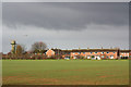
RAF Scampton
Housing and radar tower at RAF Scampton, seen from Horncastle Lane
Image: © Richard Croft
Taken: 9 Nov 2010
0.06 miles
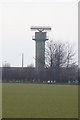
2
Dark skies over Scampton
Dark rainclouds and a howling easterly wind over RAF Scampton as one of The Red Arrows lands (by the windsock)
Image: © Richard Croft
Taken: 9 Nov 2010
0.11 miles
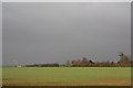
3
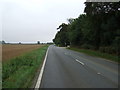
Farmland towards RAF Scampton
North of the B1500.
Image: © JThomas
Taken: 6 Sep 2014
0.15 miles
6
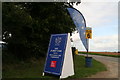
British Riding Clubs' Championships 2015, Lincolnshire Showground
With over 1600 horses, this is thought to be the country's biggest equestrian gathering.
Image: © Chris
Taken: 5 Sep 2015
0.25 miles