IMAGES TAKEN NEAR TO
Vulcan Drive, LINCOLN, LN1 2TD
Introduction
This page details the photographs taken nearby to Vulcan Drive, LN1 2TD by members of the Geograph project.
The Geograph project started in 2005 with the aim of publishing, organising and preserving representative images for every square kilometre of Great Britain, Ireland and the Isle of Man.

There are currently over 7.5m images from over14,400 individuals and you can help contribute to the project by visiting https://www.geograph.org.uk
Image Map (Loading...)


Getting Data...Please wait
Leaflet Map data © OpenStreetMap
Images are licensed for reuse under creativecommons.org/licenses/by-sa/2.0
Notes
- Clicking on the map will re-center to the selected point.
- The higher the marker number, the further away the image location is from the centre of the postcode.
Image Listing (9 Images Found)
Images are licensed for reuse under creativecommons.org/licenses/by-sa/2.0
Image
Details
Distance
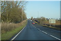
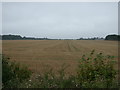
3
Looking towards RAF Scampton from Scampton Way
Image: © Ian S
Taken: 2 Mar 2011
0.17 miles
4
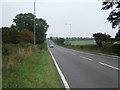
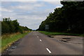
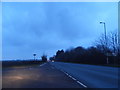
A15 heading north
Ermine Street Roman Road towards Scunthorpe.
Image: © JThomas
Taken: 6 Sep 2014
0.19 miles
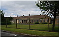
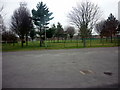
8
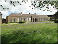
Old station headquarters at RAF Scampton
Taken through the fence from Gibson Drive.
Image: © Adrian S Pye
Taken: 7 Jun 2017
0.23 miles