IMAGES TAKEN NEAR TO
Ballerini Way, LINCOLN, LN1 2QY
Introduction
This page details the photographs taken nearby to Ballerini Way, LN1 2QY by members of the Geograph project.
The Geograph project started in 2005 with the aim of publishing, organising and preserving representative images for every square kilometre of Great Britain, Ireland and the Isle of Man.

There are currently over 7.5m images from over14,400 individuals and you can help contribute to the project by visiting https://www.geograph.org.uk
Image Map (Loading...)


Getting Data...Please wait
Leaflet Map data © OpenStreetMap
Images are licensed for reuse under creativecommons.org/licenses/by-sa/2.0
Notes
- Clicking on the map will re-center to the selected point.
- The higher the marker number, the further away the image location is from the centre of the postcode.
Image Listing (22 Images Found)
Images are licensed for reuse under creativecommons.org/licenses/by-sa/2.0
Image
Details
Distance
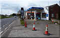
1
Saxilby Service Station
On the A57 Lincoln Road at Saxilby
Image: © Richard Croft
Taken: 18 Mar 2007
0.08 miles
2
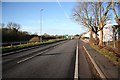
Lincoln Road
An unusually quiet Lincoln Road (A57) looking west at Saxilby
Image: © Richard Croft
Taken: 22 Nov 2008
0.09 miles
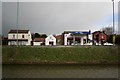
4
Building plot
Large and empty house, 18 Lincoln Road, surrounded by Harris fencing and cleared of its garden .... no doubt destined to be surrounded by new houses.
Image: © Richard Croft
Taken: 22 Nov 2008
0.11 miles
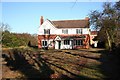
5

Saxilby illuminations
Brightly lit festive house on Mill Lane
Image: © Richard Croft
Taken: 3 Dec 2007
0.11 miles
6
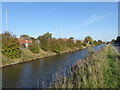
The Fossdyke Navigation at Saxilby
The Romans built the Fossdyke in around 120 AD to connect the River Witham to the River Trent. This canal therefore has a longer history than most others. After the departure of the Roman army the works decayed until the channel was scoured out in 1121, in the reign of Henry I. During the next few centuries it silted up several times, becoming almost unusable until cleaned again. It was not until 1744 that a reliable channel was created and maintained.
The canal was leased to the Great Northern Railway in 1846. Competition led to commercial decline, but agricultural produce was still being routinely carried by sailing keels and barges from the River Trent right up to the 1970s.
The canal was leased to the Great Northern Railway in 1846, but competition led to commercial decline, although agricultural produce was still being routinely carried by sailing keels and barges from the River Trent right up until the 1970s. It is still used by leisure craft.
Construction of a footpath and cycleway beside the canal from Lincoln to Saxilby has been carried out by the Lincolnshire Waterways Partnership, a joint initiative by Lincolnshire County Council, the Environment Agency and British Waterways. For much of its route it runs along the top of the northern floodbank, but drops down to a new crossing of the A57 road and a new bridge across the River Till near Saxilby. The route was officially opened on 26th July 2011. Extending the path to Torksey is a longer term aim. In this view from the south bank, the very busy A57 (Lincoln Road) is on the other side.
A full history can be seen at https://en.wikipedia.org/wiki/Foss_Dyke
A map and more information can be seen at https://canalrivertrust.org.uk/enjoy-the-waterways/canal-and-river-network/fossdyke-navigation?gclid=EAIaIQobChMI7vOGjcby3QIVlQ4rCh1UfgDREAAYASAAEgKZ3vD_BwE
Image: © Marathon
Taken: 29 Sep 2018
0.11 miles
7
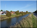
The Fossdyke Navigation at Saxilby
The Romans built the Fossdyke in around 120 AD to connect the River Witham to the River Trent. This canal therefore has a longer history than most others. After the departure of the Roman army the works decayed until the channel was scoured out in 1121, in the reign of Henry I. During the next few centuries it silted up several times, becoming almost unusable until cleaned again. It was not until 1744 that a reliable channel was created and maintained.
The canal was leased to the Great Northern Railway in 1846. Competition led to commercial decline, but agricultural produce was still being routinely carried by sailing keels and barges from the River Trent right up to the 1970s.
The canal was leased to the Great Northern Railway in 1846, but competition led to commercial decline, although agricultural produce was still being routinely carried by sailing keels and barges from the River Trent right up until the 1970s. It is still used by leisure craft.
Construction of a footpath and cycleway beside the canal from Lincoln to Saxilby has been carried out by the Lincolnshire Waterways Partnership, a joint initiative by Lincolnshire County Council, the Environment Agency and British Waterways. For much of its route it runs along the top of the northern floodbank, but drops down to a new crossing of the A57 road and a new bridge across the River Till near Saxilby. The route was officially opened on 26th July 2011. Extending the path to Torksey is a longer term aim. In this view from the south bank, the very busy A57 (Lincoln Road) is on the other side.
A full history can be seen at https://en.wikipedia.org/wiki/Foss_Dyke
A map and more information can be seen at https://canalrivertrust.org.uk/enjoy-the-waterways/canal-and-river-network/fossdyke-navigation?gclid=EAIaIQobChMI7vOGjcby3QIVlQ4rCh1UfgDREAAYASAAEgKZ3vD_BwE
Image: © Marathon
Taken: 29 Sep 2018
0.12 miles
9
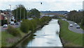
Fossdyke Canal in Saxilby
Looking east from the A57 Lincoln Road bridge.
Image: © Mat Fascione
Taken: 30 Apr 2016
0.12 miles
10
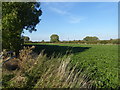
Fields east of Saxilby
This is the view from the end of Daubeney Avenue, on the eastern edge of Saxilby, looking towards Eastfield House Farm.
Image: © Marathon
Taken: 29 Sep 2018
0.13 miles