IMAGES TAKEN NEAR TO
Mill Lane, LINCOLN, LN1 2QG
Introduction
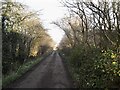
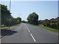
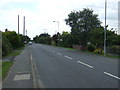
This page details the photographs taken nearby to Mill Lane, LN1 2QG by members of the Geograph project.
The Geograph project started in 2005 with the aim of publishing, organising and preserving representative images for every square kilometre of Great Britain, Ireland and the Isle of Man.

There are currently over 7.5m images from over14,400 individuals and you can help contribute to the project by visiting https://www.geograph.org.uk
Image Map
Images are licensed for reuse under creativecommons.org/licenses/by-sa/2.0
Notes
- Clicking on the map will re-center to the selected point.
- The higher the marker number, the further away the image location is from the centre of the postcode.
Image Listing (11 Images Found)
Images are licensed for reuse under creativecommons.org/licenses/by-sa/2.0
Image
Details
Distance
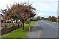
2
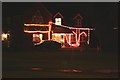
Saxilby illuminations
Brightly lit festive house on Mill Lane
Image: © Richard Croft
Taken: 3 Dec 2007
0.16 miles
5
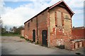
Stables at the Ship
Former stabling at the Ship Inn http://www.geograph.org.uk/photo/369698
Image: © Richard Croft
Taken: 9 Apr 2008
0.22 miles
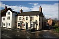
6
The Sun Inn, Saxilby
Historic Inn by the Fosdyke at Saxilby
Image: © Richard Croft
Taken: 18 Mar 2007
0.23 miles
7
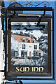
The Sun Inn sign
At The Sun Inn http://www.geograph.org.uk/photo/369701 by the Fosdyke at Saxilby
Image: © Richard Croft
Taken: 16 Jun 2010
0.23 miles
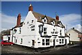
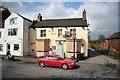
8
The Ship, Saxilby
One of two adjacent pubs by the Fosdyke canal at Saxilby
Image: © Richard Croft
Taken: 18 Mar 2007
0.23 miles
9
The Ship
The Ship Inn http://www.geograph.org.uk/photo/369698 now closed and boarded up
Image: © Richard Croft
Taken: 9 Apr 2008
0.23 miles