IMAGES TAKEN NEAR TO
Hardwick, LINCOLN, LN1 2PB
Introduction
This page details the photographs taken nearby to LN1 2PB by members of the Geograph project.
The Geograph project started in 2005 with the aim of publishing, organising and preserving representative images for every square kilometre of Great Britain, Ireland and the Isle of Man.

There are currently over 7.5m images from over14,400 individuals and you can help contribute to the project by visiting https://www.geograph.org.uk
Image Map
Images are licensed for reuse under creativecommons.org/licenses/by-sa/2.0
Notes
- Clicking on the map will re-center to the selected point.
- The higher the marker number, the further away the image location is from the centre of the postcode.
Image Listing (9 Images Found)
Images are licensed for reuse under creativecommons.org/licenses/by-sa/2.0
Image
Details
Distance
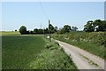
1
Hardwick Wood Farm Lane
Wood Farm cottages and the end of the maintainable highway
Image: © Richard Croft
Taken: 31 May 2009
0.02 miles
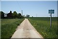
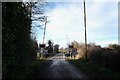
2
Hardwick Wood Farm Lane
Narrow lane leading to Hardwick Wood Farm
Image: © Richard Croft
Taken: 31 May 2009
0.11 miles
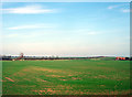
4
Sykes Lane level-crossing
Rural un-gated crossing on the lane to Hardwick Wood Farm
Image: © Richard Croft
Taken: 31 May 2009
0.18 miles
5
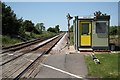
Sykes Lane level crossing
Now with gates and lights
Image: © David Brown
Taken: 30 Dec 2024
0.19 miles
6
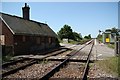
Sykes Lane level-crossing
Un-gated crossing and boarded up house, presumably originally provided for the crossing keeper
Image: © Richard Croft
Taken: 31 May 2009
0.20 miles
7
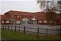
Shared General Practice Surgery Buildings in Sykes Lane
Image: © Dennis Prangnell
Taken: 10 Dec 2005
0.24 miles
8
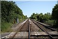
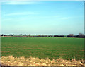
Line to Saxilby
Railway lines to Lincoln from Sykes Lane crossing http://www.geograph.org.uk/photo/1330634 next stop Saxilby
Image: © Richard Croft
Taken: 31 May 2009
0.24 miles