IMAGES TAKEN NEAR TO
Poplar Drive, The Elms, LINCOLN, LN1 2NW
Introduction
This page details the photographs taken nearby to Poplar Drive, The Elms, LN1 2NW by members of the Geograph project.
The Geograph project started in 2005 with the aim of publishing, organising and preserving representative images for every square kilometre of Great Britain, Ireland and the Isle of Man.

There are currently over 7.5m images from over14,400 individuals and you can help contribute to the project by visiting https://www.geograph.org.uk
Image Map
Images are licensed for reuse under creativecommons.org/licenses/by-sa/2.0
Notes
- Clicking on the map will re-center to the selected point.
- The higher the marker number, the further away the image location is from the centre of the postcode.
Image Listing (18 Images Found)
Images are licensed for reuse under creativecommons.org/licenses/by-sa/2.0
Image
Details
Distance
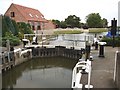
1
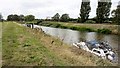
Approaching Torksey Lock by Fossdyke Navigation
Image: © Chris Morgan
Taken: 17 Aug 2018
0.05 miles
2
The Fossdyke Navigation near Torksey Lock
Cottam Power Station is in the distance
Image: © Graham Hogg
Taken: 17 Aug 2018
0.07 miles
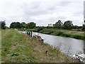
4
Path along the bank of the Fossdyke Canal
The canal is eleven and a quarter miles long. It runs south east from the River Trent at Torksey Junction to the city of Lincoln.
Image: © Mat Fascione
Taken: 30 Apr 2016
0.11 miles
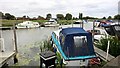
5
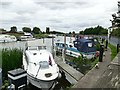
Boats on the Fossdyke Navigation at Torksey Lock
Image: © Graham Hogg
Taken: 17 Aug 2018
0.15 miles
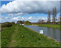
6
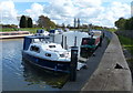
Boats moored along the Fossdyke Canal
Close to Torksley Lock at the western end of the eleven and a quarter mile long Fossdyke Canal, near Torksey Junction where it joins the River Trent.
Image: © Mat Fascione
Taken: 30 Apr 2016
0.15 miles
7
Boats moored along the Fossdyke Canal
Close to Torksley Lock at the western end of the eleven and a quarter mile long Fossdyke Canal, near Torksey Junction where it joins the River Trent.
On the horizon are the cooling towers of Cottam Power Station.
Image: © Mat Fascione
Taken: 30 Apr 2016
0.16 miles
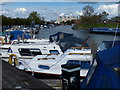
8

Boats moored along the Fossdyke Canal
Close to Torksley Lock at the western end of the eleven and a quarter mile long Fossdyke Canal, near Torksey Junction where it joins the River Trent.
Image: © Mat Fascione
Taken: 30 Apr 2016
0.20 miles
10

Edith enters the Fossdyke Navigation
From the River Trent at Torksey Lock
Image: © Chris Morgan
Taken: 17 Aug 2018
0.21 miles