IMAGES TAKEN NEAR TO
Blankney Close, LINCOLN, LN1 2JA
Introduction
This page details the photographs taken nearby to Blankney Close, LN1 2JA by members of the Geograph project.
The Geograph project started in 2005 with the aim of publishing, organising and preserving representative images for every square kilometre of Great Britain, Ireland and the Isle of Man.

There are currently over 7.5m images from over14,400 individuals and you can help contribute to the project by visiting https://www.geograph.org.uk
Image Map
Images are licensed for reuse under creativecommons.org/licenses/by-sa/2.0
Notes
- Clicking on the map will re-center to the selected point.
- The higher the marker number, the further away the image location is from the centre of the postcode.
Image Listing (29 Images Found)
Images are licensed for reuse under creativecommons.org/licenses/by-sa/2.0
Image
Details
Distance
1
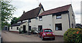
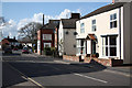
The Old Hall, 76 High Street, Saxilby
Grade II* Listed house. Whilst No.76 High Street may look like any other old cottage, an 18th century brick skin hides a genuine timber-framed open medieval hall. Built between 1480 and 1490, two and a half bays survive of an original four bayed building. The listing describes it as late 15th and 17th century with later additions but the Heritage Gateway describes it as 16th century and then states 'A large number of the original 15th century medieval timbers were revealed during the restoration of the building, reported in November 1994'.
Image: © Jo and Steve Turner
Taken: 1 Jul 2020
0.07 miles
2
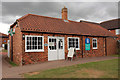
103 High Street, Saxilby
Grade II Listed mid 19th century former smithy and carpenter's workshop now a pharmacy. The Co-operative Store and Chemist stand on the site of the former home and workshop of the Hardy Family. Joiners, wheelwrights and undertakers, the business was in the family for four generations.
Image: © Jo and Steve Turner
Taken: 1 Jul 2020
0.08 miles
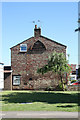
3
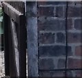
Ordnance Survey Cut Mark
This OS cut mark can be found on No121 High Street. It marks a point 11.269m above mean sea level.
Image: © Adrian Dust
Taken: 21 Jul 2017
0.11 miles
4
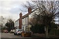
South Parade, Saxilby
Early suburban development in this commuter village.
Image: © Jonathan Thacker
Taken: 23 Dec 2014
0.12 miles
6
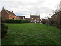
Suburban development, Saxilby
Some care has been taken in the positioning of these houses (which are in two streets) to create a miniature 'village green' effect.
Image: © Jonathan Thacker
Taken: 23 Dec 2014
0.17 miles
7
Gable end dovecote
An unusual dovecote built into the gable end of a house on the corner of High Street and Manor Road in Saxilby
Image: © Richard Croft
Taken: 16 Jun 2010
0.18 miles
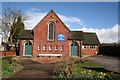
8
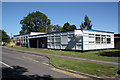
Saxilby library
The library occupies half of this building on the corner of High Street and Manor Road
Image: © Richard Croft
Taken: 16 Jun 2010
0.18 miles
9
High Street
High Street Saxilby during rush hour
Image: © Richard Croft
Taken: 8 Apr 2010
0.19 miles
10
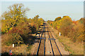
View from Saxilby Station
View NW from the footbridge at Saxilby Station
Image: © Richard Croft
Taken: 2 Nov 2016
0.19 miles