IMAGES TAKEN NEAR TO
Station Road, LINCOLN, LN1 2EB
Introduction
This page details the photographs taken nearby to Station Road, LN1 2EB by members of the Geograph project.
The Geograph project started in 2005 with the aim of publishing, organising and preserving representative images for every square kilometre of Great Britain, Ireland and the Isle of Man.

There are currently over 7.5m images from over14,400 individuals and you can help contribute to the project by visiting https://www.geograph.org.uk
Image Map
Images are licensed for reuse under creativecommons.org/licenses/by-sa/2.0
Notes
- Clicking on the map will re-center to the selected point.
- The higher the marker number, the further away the image location is from the centre of the postcode.
Image Listing (12 Images Found)
Images are licensed for reuse under creativecommons.org/licenses/by-sa/2.0
Image
Details
Distance
1
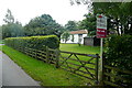
Bungalow for sale
This is a small bungalow adjacent to the former Lincoln to Retford railway, the trackbed of which forms the garden in the foreground. I wonder if this used to be a railway-related property, a crossing keeper's house perhaps?
Image: © Graham Horn
Taken: 23 Sep 2012
0.10 miles
2
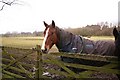
Horse on Sand Lane
An inquisitive horse in a paddock on Sand Lane near Torksey
Image: © Richard Croft
Taken: 19 Jan 2008
0.15 miles
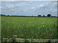
3
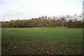
Field off sand lane
Looking across the field the line of trees and fence mark where the railway once ran. This was last used to serve an oil depot at Torksey which shut in the early 80s.
Image: © roger geach
Taken: 12 Nov 2009
0.16 miles
4
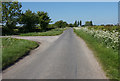
Sand Lane
Looking west near Firs Farm
Image: © Richard Croft
Taken: 19 Jan 2008
0.17 miles
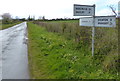
7
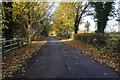
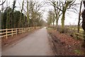
Sand Lane, near Firs Farm
This lane heads back to the A156.
Image: © Julian P Guffogg
Taken: 16 Nov 2016
0.23 miles
8
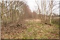
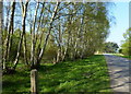
Dismantled railway
Former trackbed near Torksey, looking east
Image: © Richard Croft
Taken: 19 Jan 2008
0.23 miles