IMAGES TAKEN NEAR TO
Main Street, MABLETHORPE, LN12 2QE
Introduction
This page details the photographs taken nearby to Main Street, LN12 2QE by members of the Geograph project.
The Geograph project started in 2005 with the aim of publishing, organising and preserving representative images for every square kilometre of Great Britain, Ireland and the Isle of Man.

There are currently over 7.5m images from over14,400 individuals and you can help contribute to the project by visiting https://www.geograph.org.uk
Image Map (Loading...)


Getting Data...Please wait
Leaflet Map data © OpenStreetMap
Images are licensed for reuse under creativecommons.org/licenses/by-sa/2.0
Notes
- Clicking on the map will re-center to the selected point.
- The higher the marker number, the further away the image location is from the centre of the postcode.
Image Listing (12 Images Found)
Images are licensed for reuse under creativecommons.org/licenses/by-sa/2.0
Image
Details
Distance
1
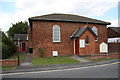
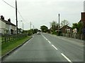
Trusthorpe Methodist Church
Early 19th century Methodist Church on Main Street
Image: © Richard Croft
Taken: 19 Aug 2011
0.06 miles


5
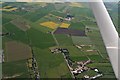
Ridge and furrow and old ditch lines between dismantled railway and Main Street, Trusthorpe: aerial 2018
Trusthorpe Hall and Trusthorpe Springs Leisure Park in/next to trees at top.
Image: © Chris
Taken: 19 May 2018
0.12 miles
6
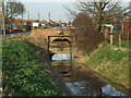
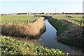
Dyke and barrier near Trusthorpe
Rather a tatty barrier but maybe it will work in extremes.
Image: © Richard Hoare
Taken: 24 Feb 2011
0.13 miles
7
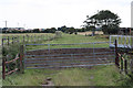
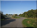
Old railway course
View SE from the site of Main Street crossing along the course of the Mablethorpe Loop Line. Opened by the Sutton and Willoughby Railway in 1877, the line closed in 1970.
Image: © Richard Croft
Taken: 19 Aug 2011
0.14 miles
8
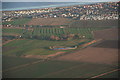
Trusthorpe, old railway and ridge and furrow: aerial 2015
In the trees ahead is crossing Farm on Main Street. The railway ran diagonally across Main Street to the left of the farm. There is virtually no trace of it to be seen from here, but plenty of ridge and furrow grassland.
Note the beach huts along the shoreline.
Image: © Chris
Taken: 8 Jan 2015
0.16 miles