IMAGES TAKEN NEAR TO
Sutton Road, MABLETHORPE, LN12 2PY
Introduction
This page details the photographs taken nearby to Sutton Road, LN12 2PY by members of the Geograph project.
The Geograph project started in 2005 with the aim of publishing, organising and preserving representative images for every square kilometre of Great Britain, Ireland and the Isle of Man.

There are currently over 7.5m images from over14,400 individuals and you can help contribute to the project by visiting https://www.geograph.org.uk
Image Map
Images are licensed for reuse under creativecommons.org/licenses/by-sa/2.0
Notes
- Clicking on the map will re-center to the selected point.
- The higher the marker number, the further away the image location is from the centre of the postcode.
Image Listing (14 Images Found)
Images are licensed for reuse under creativecommons.org/licenses/by-sa/2.0
Image
Details
Distance
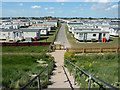
2
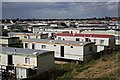
Caravan Park, Sutton on Sea
The photo was taken from the sea defence bank, the highest thing for miles around.
Image: © Tony Atkin
Taken: 17 Apr 2006
0.09 miles
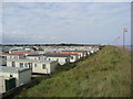
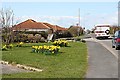
4
Greenfield Caravan Park
Holiday homes at Trusthorpe
Image: © Richard Croft
Taken: 3 May 2011
0.15 miles
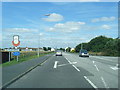
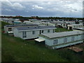
5
Heading for Trusthorpe from Sutton on Sea
Bohemia Parade can be seen on the right hand edge of the picture.
Image: © Alan Heardman
Taken: 18 Sep 2009
0.15 miles
6
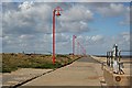
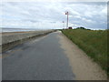
The Promenade and Sea Defence Wall
Looking north out of Sutton on Sea towards Trusthorpe.
Image: © Tony Atkin
Taken: 17 Apr 2006
0.17 miles
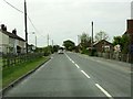
9
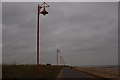
Gray day at the seaside
The cycleway between Sutton on Sea and Mablethorpe in Lincolnshire
Image: © Gary Brothwell
Taken: 29 Oct 2010
0.19 miles