IMAGES TAKEN NEAR TO
Tramway Drive, MABLETHORPE, LN12 2GS
Introduction
This page details the photographs taken nearby to Tramway Drive, LN12 2GS by members of the Geograph project.
The Geograph project started in 2005 with the aim of publishing, organising and preserving representative images for every square kilometre of Great Britain, Ireland and the Isle of Man.

There are currently over 7.5m images from over14,400 individuals and you can help contribute to the project by visiting https://www.geograph.org.uk
Image Map
Images are licensed for reuse under creativecommons.org/licenses/by-sa/2.0
Notes
- Clicking on the map will re-center to the selected point.
- The higher the marker number, the further away the image location is from the centre of the postcode.
Image Listing (16 Images Found)
Images are licensed for reuse under creativecommons.org/licenses/by-sa/2.0
Image
Details
Distance
1
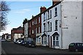
19th Century Terrace in Sutton on Sea
By far the most characteristic type of housing in Sutton on Sea is the 20th century bungalow, however there is a scattering of older houses including a couple of terraces like this one.
Image: © Tony Atkin
Taken: 17 Apr 2006
0.21 miles
2

Park Road West in Sutton on Sea
Looking north-eastward.
Image: © Peter Wood
Taken: 26 Feb 2019
0.21 miles
3
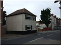
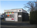
Tramway Lodge on Alford Road Sutton on Sea
Presumed to be the ticket office at the end of the former tramway.
Image: © Richard Hoare
Taken: 21 Sep 2009
0.23 miles
4

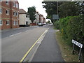
Alford Road (A1111) leading into High Street (A52) at Sutton on Sea
Looking north-eastward.
Image: © Peter Wood
Taken: 26 Feb 2019
0.23 miles
6
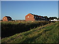
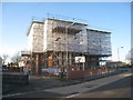
Unfinished Housing Estate Alford Road Sutton on Sea
Perhaps a sign of current economic times.
Image: © Richard Hoare
Taken: 20 Sep 2009
0.24 miles
8
Scaffolding up, work under way
Sutton on Sea Methodist church was hit by a bolt of lightning on 15th June 2012. Repairs are now under way. Image gives some indication of the extent of the damage.
Image: © Jonathan Thacker
Taken: 1 Jan 2013
0.25 miles
9
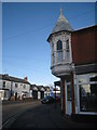
Corner turret, Station Road/High Street
Image: © Jonathan Thacker
Taken: 1 Jan 2013
0.25 miles
10
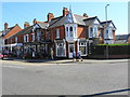
Knicks Knacks Emporium and Pamela's Hairstyles
Image: © John M
Taken: 19 Apr 2018
0.25 miles