IMAGES TAKEN NEAR TO
Mablethorpe Road, MABLETHORPE, LN12 1NQ
Introduction
This page details the photographs taken nearby to Mablethorpe Road, LN12 1NQ by members of the Geograph project.
The Geograph project started in 2005 with the aim of publishing, organising and preserving representative images for every square kilometre of Great Britain, Ireland and the Isle of Man.

There are currently over 7.5m images from over14,400 individuals and you can help contribute to the project by visiting https://www.geograph.org.uk
Image Map (Loading...)


Getting Data...Please wait
Leaflet Map data © OpenStreetMap
Images are licensed for reuse under creativecommons.org/licenses/by-sa/2.0
Notes
- Clicking on the map will re-center to the selected point.
- The higher the marker number, the further away the image location is from the centre of the postcode.
Image Listing (3 Images Found)
Images are licensed for reuse under creativecommons.org/licenses/by-sa/2.0
Image
Details
Distance
1
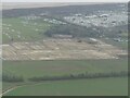
Former Theddlethorpe North Sea Gas Terminal: aerial 2023 (2)
Image: © Simon Tomson
Taken: 6 Jan 2023
0.18 miles
2
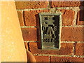
Ordnance Survey Flush Bracket G4694
This bracket can be found on the wall of a private dwelling beside Mablethorpe Road (A1031). The benchmark height has been recorded as 2.506 metres above sea level.
For more detail see : https://www.bench-marks.org.uk/bm13504
Image: © Peter Wood
Taken: 26 Feb 2019
0.18 miles
3
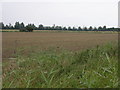
Fields and Gas Works
The industrial chimneys on the horizon are part of the gas terminal in the next square north.
Image: © Michael Patterson
Taken: 26 Aug 2006
0.24 miles