IMAGES TAKEN NEAR TO
Orchard Street, LINCOLN, LN1 1XX
Introduction
This page details the photographs taken nearby to Orchard Street, LN1 1XX by members of the Geograph project.
The Geograph project started in 2005 with the aim of publishing, organising and preserving representative images for every square kilometre of Great Britain, Ireland and the Isle of Man.

There are currently over 7.5m images from over14,400 individuals and you can help contribute to the project by visiting https://www.geograph.org.uk
Image Map (Loading...)


Getting Data...Please wait
Leaflet Map data © OpenStreetMap
Images are licensed for reuse under creativecommons.org/licenses/by-sa/2.0
Notes
- Clicking on the map will re-center to the selected point.
- The higher the marker number, the further away the image location is from the centre of the postcode.
Image Listing (1234 Images Found)
Images are licensed for reuse under creativecommons.org/licenses/by-sa/2.0
Image
Details
Distance
1
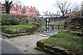
West Gate
The remains of the lower west gate of Roman Lincoln
Image: © Richard Croft
Taken: 24 Mar 2007
0.02 miles
2
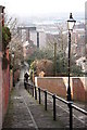
Motherby Hill
When Roman Lincoln extended beyond its original square walls, a large block of land running down to what is now Newland was enclosed; these walls were rebuilt in the Middle Ages and extended to the Brayford Pool. Motherby Hill follows the line of the wall on the west side, here looking steeply up toward the Castle from West Parade. The line can still mostly be followed south (i.e. behind the photographer), ending on Lucy Tower Street. See also Image
Image: © Ian Carrington
Taken: 20 Jan 2006
0.02 miles
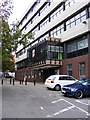
3
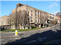
Police HQ
Known locally as Ryvita House
Image: © Ian Carrington
Taken: 20 Jan 2006
0.02 miles
4
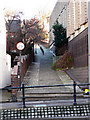
Looking down Motherby Hill
Looking south down Motherby Hill, this ancient walkway follows the line of the Roman wall to the lower town and connects Spring Hill with West Parade http://www.geograph.org.uk/photo/108448
Image: © Richard Croft
Taken: 15 Feb 2006
0.02 miles
6
Colonia wall
Scheduled Ancient Monument and grade 1 listed remains of the 3rd century west gate and 1st century walls of the lower Roman Lindum Colonia.
Image: © Richard Croft
Taken: 21 Jan 2012
0.03 miles
7
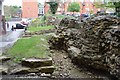
Roman Lincoln - Western Defensive Gate
The remains of the western gate partly underneath the council building. The 4th C gate would seen tradesmen, locals and soldiers come in and out of the inner city. There are several bits of reused decorated stone about, the finest has been removed for safe keeping.
Image: © Ashley Dace
Taken: 4 May 2012
0.03 miles
8

Lancaster House, West Parade, Lincoln
Dull office block that at the time housed a job centre but which has since been taken over by Lincolnshire County Council.
Image: © Stephen Richards
Taken: 14 Jun 2015
0.03 miles
9

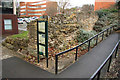
City of Lincoln Council Offices, built over Roman ruins
A rather unusual situation, but certainly better than demolishing the ruins. There are various information boards here, and the underpass makes up part of Lincoln's historical walking route.
Image: © Oliver Mills
Taken: 13 Oct 2020
0.03 miles
10
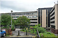
Council offices, Orchard Street, Lincoln
Built as a speculative office block by John Roberts Associates in 1971. The updated Pevsner guide frothed at the mouth to an unusual degree: "absolutely nothing to recommend it ... it offends the Lincoln skyline and is an insult to the civic pride befitting the seat of local government."
Offices of Lincolnshire County Council.
Image: © Stephen Richards
Taken: 14 Jun 2015
0.03 miles