IMAGES TAKEN NEAR TO
Blenheim Road, LINCOLN, LN1 1PU
Introduction
This page details the photographs taken nearby to Blenheim Road, LN1 1PU by members of the Geograph project.
The Geograph project started in 2005 with the aim of publishing, organising and preserving representative images for every square kilometre of Great Britain, Ireland and the Isle of Man.

There are currently over 7.5m images from over14,400 individuals and you can help contribute to the project by visiting https://www.geograph.org.uk
Image Map
Images are licensed for reuse under creativecommons.org/licenses/by-sa/2.0
Notes
- Clicking on the map will re-center to the selected point.
- The higher the marker number, the further away the image location is from the centre of the postcode.
Image Listing (68 Images Found)
Images are licensed for reuse under creativecommons.org/licenses/by-sa/2.0
Image
Details
Distance
1
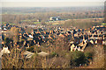
The West End
View from Carline Road over rooftops in Lincoln's West End, to the West Common and racecourse grandstand
Image: © Richard Croft
Taken: 28 Jan 2012
0.05 miles
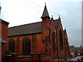
2
Queen in the West
Famous and popular pub in Lincoln's West End with countless citations in the CAMRA 'Good Beer Guides' over the years, popular with locals and Lincoln University students alike. The Grade II listed stone building is early 19th century.
Image: © Richard Croft
Taken: 14 Apr 2009
0.09 miles
3
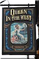
The sign of The Queen in the West
Pub sign at Lincoln's famous West End hostelry http://www.geograph.org.uk/photo/1251951
Image: © Richard Croft
Taken: 14 Apr 2009
0.09 miles
4
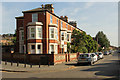
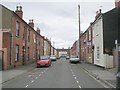
West Parade
Houses on West Parade from Alderman's Walk
Image: © Richard Croft
Taken: 28 Sep 2013
0.10 miles
5

Face in the gable
A re-set carved stone head in the gable of the Queen in the West http://www.geograph.org.uk/photo/1251951 keeping an eye on the comings and goings of its customers
Image: © Richard Croft
Taken: 14 Apr 2009
0.10 miles
7
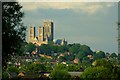
Yarborough Hill
Housing climbs the hillside dominated by the West front of the Minster in the background.
Image: © Donnylad
Taken: 23 Jun 2007
0.11 miles
9
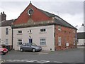
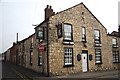
Lincoln Equitable Co-operative Industrial Society Ltd No 10 Branch - Gresham Street
Image: © Betty Longbottom
Taken: 5 Sep 2009
0.12 miles
10
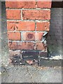
Cut Mark: Lincoln, 3 Albert Crescent
Cut mark on the brick pillar separating the entrance of No.3 from a passage to the rear. See https://www.geograph.org.uk/photo/6132060 for a wider view and https://www.bench-marks.org.uk/bm106981 for details.
Image: © Brian Westlake
Taken: 24 Apr 2019
0.12 miles