IMAGES TAKEN NEAR TO
May Crescent, LINCOLN, LN1 1LP
Introduction
This page details the photographs taken nearby to May Crescent, LN1 1LP by members of the Geograph project.
The Geograph project started in 2005 with the aim of publishing, organising and preserving representative images for every square kilometre of Great Britain, Ireland and the Isle of Man.

There are currently over 7.5m images from over14,400 individuals and you can help contribute to the project by visiting https://www.geograph.org.uk
Image Map
Images are licensed for reuse under creativecommons.org/licenses/by-sa/2.0
Notes
- Clicking on the map will re-center to the selected point.
- The higher the marker number, the further away the image location is from the centre of the postcode.
Image Listing (173 Images Found)
Images are licensed for reuse under creativecommons.org/licenses/by-sa/2.0
Image
Details
Distance
2
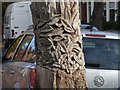
Cambridge Avenue, Lincoln
Carved tree trunk.
Image: © Dave Hitchborne
Taken: 27 Oct 2007
0.05 miles
4
Cambridge Avenue, Lincoln
I was drawn to the dead tree, which didn't look how a dead tree should. Close-up I saw that it had been very well carved. http://www.geograph.org.uk/photo/600869
Image: © Dave Hitchborne
Taken: 27 Oct 2007
0.06 miles
5
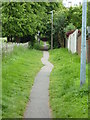
Aldermans Walk
Ancient thoroughfare beside the West Common
Image: © Richard Croft
Taken: 30 May 2019
0.06 miles
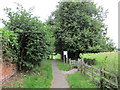
6
Aldermans Walk
Ancient thoroughfare beside the West Common
Image: © Richard Croft
Taken: 30 May 2019
0.06 miles
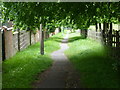
7
Alderman's Walk
Runs alongside West Common.
Image: © Jonathan Thacker
Taken: 25 Aug 2015
0.06 miles
8
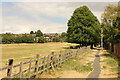
Aldermans Walk & West Common
After weeks of drought, parched grass on Aldermans Walk and West Common
Image: © Richard Croft
Taken: 15 Jul 2022
0.07 miles
9
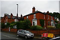
Lincoln: houses at junction of Yarborough Road and Carline Road
Image: © Christopher Hilton
Taken: 25 Jun 2019
0.08 miles
10
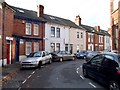
Ely Street, Lincoln
This cul-de-sac is more in this square than the map gives it credit for. The street backs onto a large area of common land, part of which was a race course.
Image: © Dave Hitchborne
Taken: 27 Oct 2007
0.08 miles