IMAGES TAKEN NEAR TO
Theodore Street, LINCOLN, LN1 1HW
Introduction
This page details the photographs taken nearby to Theodore Street, LN1 1HW by members of the Geograph project.
The Geograph project started in 2005 with the aim of publishing, organising and preserving representative images for every square kilometre of Great Britain, Ireland and the Isle of Man.

There are currently over 7.5m images from over14,400 individuals and you can help contribute to the project by visiting https://www.geograph.org.uk
Image Map (Loading...)


Getting Data...Please wait
Leaflet Map data © OpenStreetMap
Images are licensed for reuse under creativecommons.org/licenses/by-sa/2.0
Notes
- Clicking on the map will re-center to the selected point.
- The higher the marker number, the further away the image location is from the centre of the postcode.
Image Listing (370 Images Found)
Images are licensed for reuse under creativecommons.org/licenses/by-sa/2.0
Image
Details
Distance
1
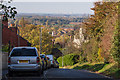
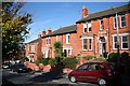
Upper Long Leys Road, Lincoln
A particularly delightful road in Lincoln, passing the Museum of Lincolnshire Life, and connecting to Yarborough Road further down the hill. The views seen when walking down the road extend an impressive distance, framed by trees on one side of the road and the roofs and chimneys of terraced houses on the other. On the horizon is West Burton Power Station.
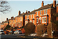
These houses have beautiful bay windows, all very well-kept and vividly painted.
Image: © Oliver Mills
Taken: 31 Oct 2018
0.05 miles
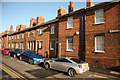
2
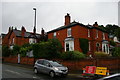
Lincoln: houses at junction of Yarborough Road and Carline Road
Image: © Christopher Hilton
Taken: 25 Jun 2019
0.05 miles
3
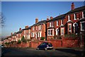
Carline Road
Early 20th century houses on Carline Road
Image: © Richard Croft
Taken: 7 Feb 2007
0.06 miles
4
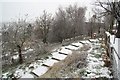
Liquorice Park
Snow covered steps from Carline Road to Yarborough Road through Liquorice Park
Image: © Richard Croft
Taken: 22 Dec 2009
0.06 miles
5
Carline Road
Edwardian villas on Carline Road
Image: © Richard Croft
Taken: 7 Feb 2012
0.06 miles
7
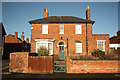
Elm House
Grade II listed house, c1857 on the corner of Upper Long Leys Road and Mill Road
Image: © Richard Croft
Taken: 28 Jan 2012
0.08 miles
9
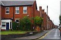
Carline Road
Warm red-brick, early 20th century houses on Carline Road
Image: © Richard Croft
Taken: 29 Oct 2008
0.08 miles
10
Mill Road
Seven grade II listed houses on Mill Road, built c1857 as the Lincolnshire Regimental band rehearsal rooms, later converted to houses
Image: © Richard Croft
Taken: 28 Jan 2012
0.08 miles