IMAGES TAKEN NEAR TO
Milfoil Avenue, LINCOLN, LN1 1AX
Introduction
This page details the photographs taken nearby to Milfoil Avenue, LN1 1AX by members of the Geograph project.
The Geograph project started in 2005 with the aim of publishing, organising and preserving representative images for every square kilometre of Great Britain, Ireland and the Isle of Man.

There are currently over 7.5m images from over14,400 individuals and you can help contribute to the project by visiting https://www.geograph.org.uk
Image Map (Loading...)


Getting Data...Please wait
Leaflet Map data © OpenStreetMap
Images are licensed for reuse under creativecommons.org/licenses/by-sa/2.0
Notes
- Clicking on the map will re-center to the selected point.
- The higher the marker number, the further away the image location is from the centre of the postcode.
Image Listing (49 Images Found)
Images are licensed for reuse under creativecommons.org/licenses/by-sa/2.0
Image
Details
Distance
1
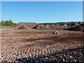
Site clearance
The former E2V site http://www.geograph.org.uk/photo/2479767 cleared for development
Image: © Richard Croft
Taken: 15 Oct 2011
0.04 miles
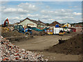
2

Demolition site
The end of the former E2V works on Carholme Road, seen from NCN route 64 by the Fossdyke. The engineering works closed in early 2011 and the site sold to Stamford Homes for development. Most of the production was relocated to Chelmsford and a new site off Doddington Road in Lincoln
Image: © Richard Croft
Taken: 27 Jun 2011
0.04 miles
3

E2V demolition
Continuing clearance of the former E2V site http://www.geograph.org.uk/photo/2479767
Image: © Richard Croft
Taken: 17 Aug 2011
0.05 miles

5
E2V demolition
Continuing demolition of the former E2V site http://www.geograph.org.uk/photo/2479767
Image: © Richard Croft
Taken: 17 Aug 2011
0.06 miles
6

Former Factory Gateposts on Carholme Road
A pair of gateposts of the former entrance of a timber merchant premises, later British Thompson-Houston. Housing is now on the factory site. The right-hand post carries a cut benchmark. See https://www.geograph.org.uk/photo/7468080 for a closer view and https://www.bench-marks.org.uk/bm190962 for details of the mark.
Image: © Brian Westlake
Taken: 25 Apr 2023
0.06 miles
7

Cut Mark on Gatepost on Carholme Road
One of a pair of gateposts of the former entrance of a timber merchant premises, later British Thompson-Houston. The post carries a cut benchmark. See https://www.geograph.org.uk/photo/7468084 for a wider view and https://www.bench-marks.org.uk/bm190962 for details of the mark.
Image: © Brian Westlake
Taken: 25 Apr 2023
0.06 miles
8
Site clearance
The former E2V site http://www.geograph.org.uk/photo/2576596 awaiting redevelopment
Image: © Richard Croft
Taken: 15 Oct 2011
0.07 miles
9

Demolition site
The end of the former E2V works on Carholme Road, seen from NCN route 64 by the Fossdyke. The engineering works closed in early 2011 and the site sold to Stamford Homes for development. Most of the production was relocated to Chelmsford and a new site off Doddington Road in Lincoln
Image: © Richard Croft
Taken: 27 Jun 2011
0.07 miles
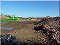
10

E2V demolition
The crushed remains of bricks from the E2V site http://www.geograph.org.uk/photo/2479767
Image: © Richard Croft
Taken: 17 Aug 2011
0.08 miles