IMAGES TAKEN NEAR TO
Harricot Close, LINCOLN, LN1 1AE
Introduction
This page details the photographs taken nearby to Harricot Close, LN1 1AE by members of the Geograph project.
The Geograph project started in 2005 with the aim of publishing, organising and preserving representative images for every square kilometre of Great Britain, Ireland and the Isle of Man.

There are currently over 7.5m images from over14,400 individuals and you can help contribute to the project by visiting https://www.geograph.org.uk
Image Map (Loading...)


Getting Data...Please wait
Leaflet Map data © OpenStreetMap
Images are licensed for reuse under creativecommons.org/licenses/by-sa/2.0
Notes
- Clicking on the map will re-center to the selected point.
- The higher the marker number, the further away the image location is from the centre of the postcode.
Image Listing (11 Images Found)
Images are licensed for reuse under creativecommons.org/licenses/by-sa/2.0
Image
Details
Distance
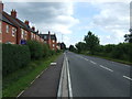
1
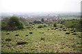
Higson Road view
View over the Cliff from the footpath at Higson Road
Image: © Richard Croft
Taken: 14 Apr 2009
0.17 miles
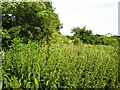
3
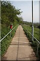
Cliffside footpath
Path descending to new housing on the old St.George's hospital site
Image: © Richard Croft
Taken: 14 Apr 2009
0.19 miles
8
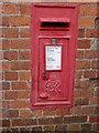
Lincoln, Sobraon Barracks
Post box with OS cut bench mark below on a former WD building at the north-west corner of Sobraon Barracks. See http://www.geograph.org.uk/photo/5122395 for a wider view and http://www.bench-marks.org.uk/bm30112 for details of the mark.
Image: © Brian Westlake
Taken: 28 Aug 2016
0.24 miles
9
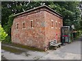
Sobraon Barracks, Lincoln
This former WD building carries a post box and OS cut bench mark on the right-hand face. See http://www.geograph.org.uk/photo/5122386 for a close-up and http://www.bench-marks.org.uk/bm30112 for details of the mark.
Image: © Brian Westlake
Taken: 28 Aug 2016
0.24 miles
10
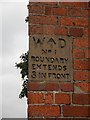
Lincoln, Sobraon Barracks, boundary stone
Boundary stone set in the angle of a building at the north-west corner of Sobraon Barracks, Lincoln. See http://www.geograph.org.uk/photo/5122395 for a wider view.
Image: © Brian Westlake
Taken: 28 Aug 2016
0.24 miles