IMAGES TAKEN NEAR TO
Simons Close, LOUTH, LN11 9TX
Introduction
This page details the photographs taken nearby to Simons Close, LN11 9TX by members of the Geograph project.
The Geograph project started in 2005 with the aim of publishing, organising and preserving representative images for every square kilometre of Great Britain, Ireland and the Isle of Man.

There are currently over 7.5m images from over14,400 individuals and you can help contribute to the project by visiting https://www.geograph.org.uk
Image Map (Loading...)


Getting Data...Please wait
Leaflet Map data © OpenStreetMap
Images are licensed for reuse under creativecommons.org/licenses/by-sa/2.0
Notes
- Clicking on the map will re-center to the selected point.
- The higher the marker number, the further away the image location is from the centre of the postcode.
Image Listing (43 Images Found)
Images are licensed for reuse under creativecommons.org/licenses/by-sa/2.0
Image
Details
Distance
1
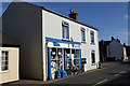
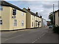
General Store, Donington on Bain
Sells a wide variety of goods.
Image: © Andrew Whale
Taken: 28 Oct 2009
0.07 miles
3
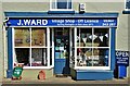
Village shop, Donington on Bain
This traditional village shop has been run by Ms Jenny Ward since 1973 - fifty years of service.
Image: © Neil Theasby
Taken: 17 Apr 2023
0.07 miles
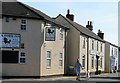
5
The Black Horse Inn, Donington-on-Bain
At the far side of the pub is a village store.
Image: © Oliver Dixon
Taken: 10 Oct 2012
0.09 miles
6
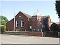
Donington on Bain Village Hall
Built 1966
Image: © J.Hannan-Briggs
Taken: 31 Jul 2011
0.09 miles
7
Pub and shop in Donington on Bain
The Black Horse Inn with a village shop a little further along.
Image: © Gordon Hatton
Taken: 20 Sep 2019
0.09 miles
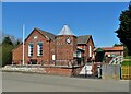
10
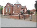
Village Hall, Donington on Bain
Situated in Main Road LN11 9TJ, this village hall dates from 1879 and was formerly known as The Old Foresters Hall, then became the Church Hall in 1905. Subsequently, it became the village hall in 1966 as indicated by the inscription above the two vertical windows. Today, it is let out for use by local organisations. A clock can be seen on the tower whilst a Union Jack flag is flying from a flagpole to the left of the photo.
Image: © David Hillas
Taken: 17 Jul 2019
0.11 miles