IMAGES TAKEN NEAR TO
Cadwell Park, LOUTH, LN11 9SE
Introduction
This page details the photographs taken nearby to Cadwell Park, LN11 9SE by members of the Geograph project.
The Geograph project started in 2005 with the aim of publishing, organising and preserving representative images for every square kilometre of Great Britain, Ireland and the Isle of Man.

There are currently over 7.5m images from over14,400 individuals and you can help contribute to the project by visiting https://www.geograph.org.uk
Image Map (Loading...)


Getting Data...Please wait
Leaflet Map data © OpenStreetMap
Images are licensed for reuse under creativecommons.org/licenses/by-sa/2.0
Notes
- Clicking on the map will re-center to the selected point.
- The higher the marker number, the further away the image location is from the centre of the postcode.
Image Listing (19 Images Found)
Images are licensed for reuse under creativecommons.org/licenses/by-sa/2.0
Image
Details
Distance
1
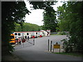
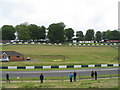
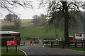
Cadwell Park, paddock
The pre-race collecting area.
Image: © E Gammie
Taken: 8 Jun 2013
0.03 miles
2
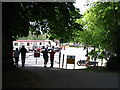
The paddock, Cadwell Park
The same view as Image, 20 years on - the shelters have been removed and buildings replaced. The competitors collect here for each race.
Image: © E Gammie
Taken: 20 May 2007
0.03 miles
3
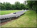
Cadwell Park, Hall Bends
After negotiating Hall Bends, competitors take a sharp right at the Hairpin and travel down towards Barn which is a right turn onto Image] .
Image: © E Gammie
Taken: 8 Jun 2013
0.05 miles
4
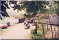
Cadwell Park paddock
Vintage motor cycles in the scrutineering area of Cadwell paddock. The track is to the left of, and below the white building. The buildings have been upgraded since this was taken on 16/17 May 1987 - see Image for a 2007 view.
Image: © E Gammie
Taken: Unknown
0.06 miles
5
Cadwell Park, top of 'The Mountain'
Before racing commences, taken from beside the paddock seating. The motorcyclist has just come over the summit of 'the mountain' and is travelling in the normal racing direction, on the full circuit. The lower track is the start/finish area for the full circuit. The hairpin for the short circuit is behind the tree in the centre.
Image: © E Gammie
Taken: Unknown
0.07 miles
6
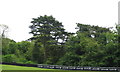
Cadwell Park, cedar
A cedar tree on the far side of Hall Bends, assumed to be part of the original parkland planting, pre-dating the racing circuit.
Image: © E Gammie
Taken: 8 Jun 2013
0.07 miles
7
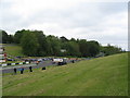
Cadwell Park, Start/Finish straight
Vehicles approaching the start line from Barn corner. They will head along the straight towards the bottom of Coppice ( http://www.geograph.org.uk/photo/3507622 ).
Image: © E Gammie
Taken: 8 Jun 2013
0.08 miles
8
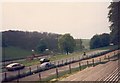
Cadwell Park
Looking across the start/finish straight to the top of The Mountain on the far side of the grassed area which once held a playground. The building to the left is the medical centre, with a helicopter landing mark adjacent. The grandstand at the left stands at the top of The Mountain. In front of the trees, to the right, are buildings in the paddock area and a cafeteria.
Image: © E Gammie
Taken: 8 Jun 2013
0.09 miles
10
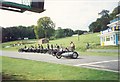
Cadwell Park, start line
Brough Superiors on display at the start/finish line of the full circuit at Cadwell, 1987
Image: © E Gammie
Taken: Unknown
0.10 miles