IMAGES TAKEN NEAR TO
Biscathorpe, LOUTH, LN11 9RA
Introduction
This page details the photographs taken nearby to LN11 9RA by members of the Geograph project.
The Geograph project started in 2005 with the aim of publishing, organising and preserving representative images for every square kilometre of Great Britain, Ireland and the Isle of Man.

There are currently over 7.5m images from over14,400 individuals and you can help contribute to the project by visiting https://www.geograph.org.uk
Image Map (Loading...)


Getting Data...Please wait
Leaflet Map data © OpenStreetMap
Images are licensed for reuse under creativecommons.org/licenses/by-sa/2.0
Notes
- Clicking on the map will re-center to the selected point.
- The higher the marker number, the further away the image location is from the centre of the postcode.
Image Listing (8 Images Found)
Images are licensed for reuse under creativecommons.org/licenses/by-sa/2.0
Image
Details
Distance
1
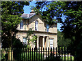
Biscathorpe House
Picture shows South front of Biscathorpe House.
Image: © David Wright
Taken: 14 Jun 2006
0.02 miles
4
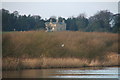
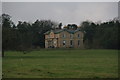
Biscathorpe House across the lake
The definitive view of Biscathorpe House - but the seagull is the star.
Image: © Chris
Taken: 19 Jan 2014
0.12 miles
5
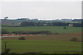
Biscathorpe House, and the River Bain
Viewed from Welsdale Road, Donington on Bain. For closer view see Image
The River Bain and the wetlands it runs through are the subject of a chalk stream restoration project:
"Donington Mill, Donington-on-Bain: re-naturalising a section of the River Bain to improve fish and eel passage...
The flow was being affected by too much fallen tree debris across the channel, slowing the flow and resulting in build-up of silt on the bed. Farmers on both sides of the bank were concerned as a long stretch of bank was being poached by livestock. The enhancements will reduce the amount of sediment entering the stream and will result in an increase of flow which will scour the bed, move the silt along the system and expose those hidden gravels. This will provide more habitat for aquatic invertebrates and spawning sites for species like brown trout. In addition the landowners will have greater control over the grazing intensity on the land and give the animals access to water from the stream no matter which section they are in."
See: http://www.glnp.org.uk/lincolnshire-landscapes/project-areas/lincolnshire-chalkstreams-project.php
Image: © Chris
Taken: 19 Jan 2014
0.12 miles
6
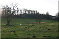
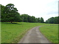
River Bain in Biscathorpe Park, looking westwards
A new and big challenge in this photogenic area is fracking. Egdon Resources has made a planning application to construct a temporary well site and flare pit, and an exploratory borehole nearby. The wording of the proposal talks about "undertaking of production tests and retaining the site and wellhead valve assembly gear for evaluation." There would also be access roads for the increased traffic from lorries. See: http://www.loutheye.co.uk/03-09-13-egdon-plans-drilling-in-biscathorpe.php
Image: © Chris
Taken: 19 Jan 2014
0.19 miles
7
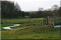
River Bain in Biscathorpe Park
Looking westwards from the Viking Way.
A new and big challenge in this photogenic area is fracking. Egdon Resources has made a planning application to construct a temporary well site and flare pit, and an exploratory borehole nearby. The wording of the proposal talks about "undertaking of production tests and retaining the site and wellhead valve assembly gear for evaluation." There would also be access roads for the increased traffic from lorries. See: http://www.loutheye.co.uk/03-09-13-egdon-plans-drilling-in-biscathorpe.php
Image: © Chris
Taken: 19 Jan 2014
0.23 miles