IMAGES TAKEN NEAR TO
Welsdale Road, LOUTH, LN11 9QZ
Introduction
This page details the photographs taken nearby to Welsdale Road, LN11 9QZ by members of the Geograph project.
The Geograph project started in 2005 with the aim of publishing, organising and preserving representative images for every square kilometre of Great Britain, Ireland and the Isle of Man.

There are currently over 7.5m images from over14,400 individuals and you can help contribute to the project by visiting https://www.geograph.org.uk
Image Map (Loading...)


Getting Data...Please wait
Leaflet Map data © OpenStreetMap
Images are licensed for reuse under creativecommons.org/licenses/by-sa/2.0
Notes
- Clicking on the map will re-center to the selected point.
- The higher the marker number, the further away the image location is from the centre of the postcode.
Image Listing (7 Images Found)
Images are licensed for reuse under creativecommons.org/licenses/by-sa/2.0
Image
Details
Distance
1
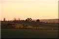
Hillside Farm from the Lindsey Trail near Glebe Farm
Image: © Chris
Taken: 19 Jan 2014
0.02 miles
2
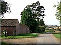
Hillside Farm
Above Donington-on-Bain.
Image: © Oliver Dixon
Taken: 10 Oct 2012
0.02 miles
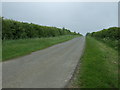
3
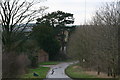
Hillside Farm on the Welsdale Road
Downhill stretch into Donington on Bain.
Image: © Chris
Taken: 19 Jan 2014
0.04 miles
6
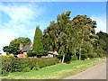
Cottage near Donington-on-Bain
The name on the gate is "Roseyne", but it is shown on the map as "The Old Rectory". The garden has a fine display of conifers.
Image: © Oliver Dixon
Taken: 10 Oct 2012
0.20 miles
