IMAGES TAKEN NEAR TO
Horncastle Road, LOUTH, LN11 9LD
Introduction
This page details the photographs taken nearby to Horncastle Road, LN11 9LD by members of the Geograph project.
The Geograph project started in 2005 with the aim of publishing, organising and preserving representative images for every square kilometre of Great Britain, Ireland and the Isle of Man.

There are currently over 7.5m images from over14,400 individuals and you can help contribute to the project by visiting https://www.geograph.org.uk
Image Map
Images are licensed for reuse under creativecommons.org/licenses/by-sa/2.0
Notes
- Clicking on the map will re-center to the selected point.
- The higher the marker number, the further away the image location is from the centre of the postcode.
Image Listing (30 Images Found)
Images are licensed for reuse under creativecommons.org/licenses/by-sa/2.0
Image
Details
Distance
1
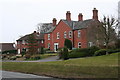
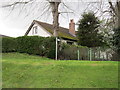
Bank House, Horncastle Road
The road into Louth runs between steep banks. Council maintenance workers have been seen guiding rotary mowers on ropes along the inclines!
Image: © Chris
Taken: 11 Apr 2013
0.06 miles
2
Development area of Horncastle Road, Louth
Work seems to have stopped.
Image: © Jonathan Thacker
Taken: 14 Oct 2023
0.06 miles
4
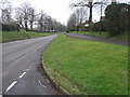
High Road and Low Road
The high road on the right is a narrow service road to the houses on the right.
Image: © Michael Patterson
Taken: 16 Feb 2007
0.10 miles
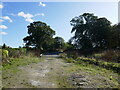
6
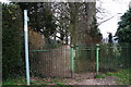
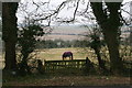
Iron gate and railings across footpath entrance
The path runs alongside the playing field of the King Edward VI School.
Image: © Chris
Taken: 11 Apr 2013
0.12 miles
7
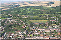
Horncastle Road, Louth, aerial 2007
The old A16 runs across the bottom, i.e. Upgate. Horncastle Road leads off left of centre, with King Edward VI School and the golf course to its right. Stenigot mast is just visible on the horizon above the stubble fields.
Image: © Chris
Taken: 5 Aug 2007
0.13 miles
8
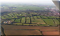
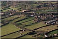
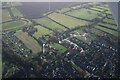
Louth West: aerial 2015
From the bottom: A16 bypass (left corner); course of former railway (horizontal, bottom of the green fields area); Horncastle Road: golf course; Hubbards Hills left edge; in top left corner is A157 (Lincoln) fork with A631 (Market Rasen); northern section of bypass; Fairfield Industrial Estate (top right corner).
To see this area and its new developments in 2022 see Image
Image: © Chris
Taken: 21 Apr 2015
0.16 miles
10
Further development on Julian Bower, Louth: aerial 2022 (1)
Image: © Chris
Taken: 25 Nov 2022
0.18 miles