IMAGES TAKEN NEAR TO
Little Lane, LOUTH, LN11 9DT
Introduction
This page details the photographs taken nearby to Little Lane, LN11 9DT by members of the Geograph project.
The Geograph project started in 2005 with the aim of publishing, organising and preserving representative images for every square kilometre of Great Britain, Ireland and the Isle of Man.

There are currently over 7.5m images from over14,400 individuals and you can help contribute to the project by visiting https://www.geograph.org.uk
Image Map (Loading...)


Getting Data...Please wait
Leaflet Map data © OpenStreetMap
Images are licensed for reuse under creativecommons.org/licenses/by-sa/2.0
Notes
- Clicking on the map will re-center to the selected point.
- The higher the marker number, the further away the image location is from the centre of the postcode.
Image Listing (104 Images Found)
Images are licensed for reuse under creativecommons.org/licenses/by-sa/2.0
Image
Details
Distance
1

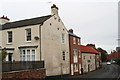
Little Lane - little change
Some houses on the corner of Little Lane are getting a makeover, some old properties have been demolished and the site awaits redevelopment.
But Sunday morning in Louth hasn't changed: this gentleman is off to the nearby Salvation Army HQ.
Image: © Chris
Taken: 14 Oct 2012
0.06 miles
2
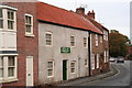
William East's house in Church Street
With his initials picked out in painted brick on the gable end of his house.
He owned the brewery just down the street. See Image
With thanks for the information to Geoff Mullett, from his book "Discovering Louth", 2010.
Image: © Chris
Taken: 14 Oct 2012
0.11 miles
3
Louth's 3 swimming pools: No.1
This was the old open air swimming pool. The water from Aswell Spring was dammed up to provide the water for it.
Now a private house.
See No.2: Image
Image: © Chris
Taken: 14 Oct 2012
0.12 miles
4

Closed for the season
You would have to wait a very long time before Louth's open air swimming pool will let you in! See Image for some history and perhaps why the property is known as Old Watermill Cottage.
Driven past it many times and not noticed the big green and white sign. Duh!
Image: © Ian Paterson
Taken: 23 Feb 2022
0.12 miles
5

Eastgate, Eastfield Road and Louth southeast: aerial 2018
Image: © Chris
Taken: 13 Mar 2018
0.13 miles
6
The destruction of the historic Winch's Brewery
Lest we should forget what has been destroyed, see Image and Image
In the 2012 photo the broken wall is seen intact and bearing the name of the brewery "T.M.Winch and Co."
This site consisted the brewery, which dated from the middle of the 19th century, and the former Allinsons Print Works and shop.
These were part of a historic row of buildings, including the brewer's house and the spring-fed swimming pool. See: Image and Image
Originally William East's brewery (he lived up the road, see TF3387 : William East's house in Church Street), it was taken over in the 1880's by T.M.Winch and Co.(as seen here). Then it continued as Soulby Sons and Winch until 1910. The water for the beer came from Aswell Spring, which flowed through the Gatherums from Aswell Street, also supplying the open air swimming pool next door.
The applicant said the property had been on the market for nearly 7 years, and not sold and that the condition was "worsening".
The Victorian Society objected strongly to the plans. Nevertheless, though the first application was not successful, East Lindsey District Council allowed the second, thus sanctioning the destruction of this historic buildings.
Housing is to be built on the site.
A similar fate befell the chimney in Cinder Lane, which after being abandoned for 7 years was declared to be unsafe, so that the Council said it had no option but to allow it to be demolished.
Image: © Chris
Taken: 22 Jul 2014
0.13 miles
7
East Alley, path to The Gatherums
This is one of three narrow, steep walkways that lead down to "The Gatherums", which is a park aligned with a path from Church St. to Aswell St.
See: Image; Image Unlike the other two, the name is self explanatory!
Image: © Chris
Taken: 22 Sep 2012
0.13 miles
8

Lest we should forget: former printworks and Winch's Brewery
This site consisted of Winch's brewery, which dated from the middle of the 19th century, and behind it, on Queen Street, the former Allinsons Print Works and shop (Image).
These were part of a historic row of buildings, including the brewer's house and the spring-fed swimming pool. See: Image and Image
Originally William East's brewery (he lived up the road, see TF3387 : William East's house in Church Street), it was taken over in the 1880's by T.M.Winch and Co.(as seen here). Then it continued as Soulby Sons and Winch until 1910. The water for the beer came from Aswell Spring, which flowed through the Gatherums from Aswell Street, also supplying the open air swimming pool next door.
The applicant said the property had been on the market for nearly 7 years, and not sold and that the condition was "worsening".
The Victorian Society objected strongly to the plans. Nevertheless, though the first application was not successful, East Lindsey District Council allowed the second, thus sanctioning the destruction of this historic buildings.
Housing is to be built on the site.
A similar fate befell the chimney in Cinder Lane, which after being abandoned for 7 years was declared to be unsafe, so that the Council said it had no option but to allow it to be demolished. To see the tragic, and shameful, transformation see: Image], Image] and Image
Image: © Chris
Taken: 10 Oct 2012
0.14 miles
9

Louth east, Eastgate and Church Street: aerial 2018
Image: © Chris
Taken: 13 Mar 2018
0.14 miles