IMAGES TAKEN NEAR TO
Gladiator Road, LOUTH, LN11 8UL
Introduction
This page details the photographs taken nearby to Gladiator Road, LN11 8UL by members of the Geograph project.
The Geograph project started in 2005 with the aim of publishing, organising and preserving representative images for every square kilometre of Great Britain, Ireland and the Isle of Man.

There are currently over 7.5m images from over14,400 individuals and you can help contribute to the project by visiting https://www.geograph.org.uk
Image Map (Loading...)


Getting Data...Please wait
Leaflet Map data © OpenStreetMap
Images are licensed for reuse under creativecommons.org/licenses/by-sa/2.0
Notes
- Clicking on the map will re-center to the selected point.
- The higher the marker number, the further away the image location is from the centre of the postcode.
Image Listing (10 Images Found)
Images are licensed for reuse under creativecommons.org/licenses/by-sa/2.0
Image
Details
Distance
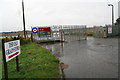
2
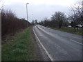
Manby Middlegate (B1200)
Heading south west.
Image: © JThomas
Taken: 21 Mar 2015
0.07 miles
5
Old Manby airfield: industrial estate
This is the entrance nearest the hangars, some of which spent many years in use as grainstores. They have now mainly been given over to light undustrial use or are to let.
The roundel on the gate is a reminder of the airfield's days of glory, though I suspect it is of recent origin.
Image: © Chris
Taken: 21 Sep 2012
0.09 miles
6
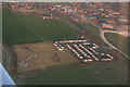
Housing estate by the B1200 running through Manby: aerial
This and adjoining patch must formerly have been part of R.A.F. Manby, the buildings and water tower of which can be seen opposite. The "quadrangle" building among these is Tedder Hall, the HQ of East Lindsey District Council.
Image: © Chris
Taken: 25 Mar 2015
0.12 miles
8
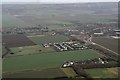
Manby west, B1200 to the sea, Gayton Windfarm: aerial 2017
Image: © Chris
Taken: 3 Dec 2017
0.19 miles
9
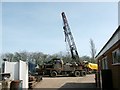
North Lincs Engineering Co
This crane has been a landmark for years. The company resides opposite Manby Showground, which was once an Airfield.
Image: © Dave Hitchborne
Taken: 31 Mar 2003
0.21 miles
10
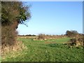
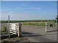
Footpath to Stewton
After leaving Grimoldby, heading west to Stewton, I went the wrong side of this hedge (left of the picture) and ended of on Grove farmland. I backtracked and eventually got onto the footpath. I noticed that others had kept to the field perimeter rather than cross the field via the correct route.
Image: © Dave Hitchborne
Taken: 1 Dec 2007
0.24 miles