IMAGES TAKEN NEAR TO
South Ormsby, LOUTH, LN11 8RF
Introduction
This page details the photographs taken nearby to LN11 8RF by members of the Geograph project.
The Geograph project started in 2005 with the aim of publishing, organising and preserving representative images for every square kilometre of Great Britain, Ireland and the Isle of Man.

There are currently over 7.5m images from over14,400 individuals and you can help contribute to the project by visiting https://www.geograph.org.uk
Image Map (4 Images)


Getting Data...Please wait
Leaflet Map data © OpenStreetMap
Images are licensed for reuse under creativecommons.org/licenses/by-sa/2.0
Notes
- Clicking on the map will re-center to the selected point.
- The higher the marker number, the further away the image location is from the centre of the postcode.
Image Listing (4 Images Found)
Images are licensed for reuse under creativecommons.org/licenses/by-sa/2.0
Image
Details
Distance
1
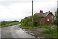
Bluestone Heath Road by Forty-Acre Plantation
Image: © Chris
Taken: 11 May 2014
0.01 miles
2
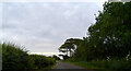
Bluestone Heath Road beside Bluestone Strip woodland
Towards South Ormsby.
Image: © JThomas
Taken: 4 Jun 2020
0.17 miles
3
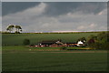
Campaign Farm from the footpath to South Ormsby
Image: © Chris
Taken: 11 May 2014
0.23 miles
4
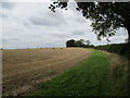
Stubble field alongside the Bluestone Heath Road
Near South Ormesby.
Image: © Jonathan Thacker
Taken: 7 Sep 2020
0.25 miles