IMAGES TAKEN NEAR TO
Hardens Gap, LOUTH, LN11 8RE
Introduction
This page details the photographs taken nearby to Hardens Gap, LN11 8RE by members of the Geograph project.
The Geograph project started in 2005 with the aim of publishing, organising and preserving representative images for every square kilometre of Great Britain, Ireland and the Isle of Man.

There are currently over 7.5m images from over14,400 individuals and you can help contribute to the project by visiting https://www.geograph.org.uk
Image Map
Images are licensed for reuse under creativecommons.org/licenses/by-sa/2.0
Notes
- Clicking on the map will re-center to the selected point.
- The higher the marker number, the further away the image location is from the centre of the postcode.
Image Listing (20 Images Found)
Images are licensed for reuse under creativecommons.org/licenses/by-sa/2.0
Image
Details
Distance
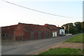
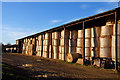
2
Harden's Gap: No.2
That's what it says on the front door. The end barn is marked No.1.
Image: © Chris
Taken: 7 Jul 2013
0.02 miles
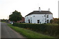
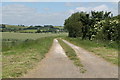
3
Harden's Gap
From the path to Willow Bank Wood.
Image: © Chris
Taken: 7 Jul 2013
0.02 miles
7
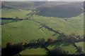
Ridge and Furrow at Harden's Gap near South Ormsby: aerial 2018
Image: © Simon Tomson
Taken: 18 Nov 2018
0.10 miles
8

Cloven Hill to Harden's Gap near S. Ormsby: aerial 2020
Image: © Chris
Taken: 30 Aug 2020
0.11 miles
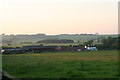
9
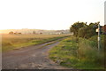
Bridleway north from Harden's Gap
Looking into the evening sun.
Image: © Chris
Taken: 7 Jul 2013
0.11 miles