IMAGES TAKEN NEAR TO
Scorer Row, LOUTH, LN11 8PP
Introduction
This page details the photographs taken nearby to Scorer Row, LN11 8PP by members of the Geograph project.
The Geograph project started in 2005 with the aim of publishing, organising and preserving representative images for every square kilometre of Great Britain, Ireland and the Isle of Man.

There are currently over 7.5m images from over14,400 individuals and you can help contribute to the project by visiting https://www.geograph.org.uk
Image Map (Loading...)


Getting Data...Please wait
Leaflet Map data © OpenStreetMap
Images are licensed for reuse under creativecommons.org/licenses/by-sa/2.0
Notes
- Clicking on the map will re-center to the selected point.
- The higher the marker number, the further away the image location is from the centre of the postcode.
Image Listing (90 Images Found)
Images are licensed for reuse under creativecommons.org/licenses/by-sa/2.0
Image
Details
Distance
1
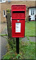
Elizabeth II postbox, Scorer Row, Burwell
Postbox No. LN11 56.
See Image] for context.
Image: © JThomas
Taken: 12 Jun 2020
0.01 miles
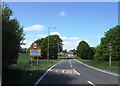
2
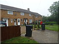
Scorer Row, Burwell
Showing position of Postbox No. LN11 56.
See Image] for postbox.
Image: © JThomas
Taken: 12 Jun 2020
0.01 miles
4
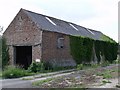
Burwell view
View from St.Michael's church to Priory Farm
Image: © Richard Croft
Taken: 23 Nov 2007
0.08 miles
6
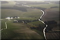
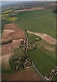
A16 Burwell to Walmsgate: aerial 2014
The wettest winter for about 200 years.
Image: © Chris
Taken: 10 Feb 2014
0.09 miles
7
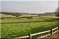
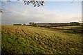
Earthworks in a paddock at Burwell
Reference on "Pastscape" is only to ridge and furrow, though there is obviously more:
"Probable Medieval or Post Medieval ridge and furrow, seen as
earthworks. Morphological description: broad ridge and furrow with
a maximum length of 100m. Centred at:-TF 3576 7913."
See: http://www.pastscape.org.uk/hob.aspx?hob_id=1050544&sort=2&rational=m&recordsperpage=10&maplat=53.29159981&maplong=0.03835373&mapisa=100&mapist=os&mapilo=0.0384&mapila=53.2916&mapiloe=e&mapilan=n&mapios=TF358791&mapigrn=379150&mapigre=535850&mapipc=#aRt
Image: © Chris
Taken: 25 Jan 2014
0.13 miles
8
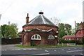
Burwell Butter Cross
Burwell was granted a market in the late 13th century, seemingly sufficiently prosperous to warrant an octagonal brick Butter Cross in the early 18th century. There's no market any more but the building now serves as the parish hall.
Image: © Richard Croft
Taken: 9 May 2007
0.16 miles
9
Burwell: aerial 2016
Buttercross on the right (east) of the A16.
Image: © Chris
Taken: 19 Apr 2016
0.16 miles
10
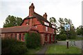
The Stags Head
Village pub at Burwell
Image: © Richard Croft
Taken: 9 May 2007
0.17 miles