IMAGES TAKEN NEAR TO
Authorpe, LOUTH, LN11 8PG
Introduction
This page details the photographs taken nearby to LN11 8PG by members of the Geograph project.
The Geograph project started in 2005 with the aim of publishing, organising and preserving representative images for every square kilometre of Great Britain, Ireland and the Isle of Man.

There are currently over 7.5m images from over14,400 individuals and you can help contribute to the project by visiting https://www.geograph.org.uk
Image Map
Images are licensed for reuse under creativecommons.org/licenses/by-sa/2.0
Notes
- Clicking on the map will re-center to the selected point.
- The higher the marker number, the further away the image location is from the centre of the postcode.
Image Listing (17 Images Found)
Images are licensed for reuse under creativecommons.org/licenses/by-sa/2.0
Image
Details
Distance
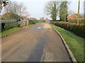
1
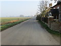
Road leaving Authorpe
Looking north-westward.
Image: © Peter Wood
Taken: 24 Feb 2019
0.02 miles
3
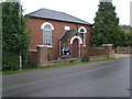
Authorpe Methodist Church
This compact and pleasingly symmetrical building is the Methodist Church in Authorpe.
Image: © Michael Patterson
Taken: 26 Aug 2006
0.10 miles
7
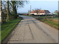
Road in Authorpe
Looking north-westward.
Image: © Peter Wood
Taken: 24 Feb 2019
0.14 miles
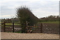
9
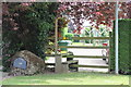
Stile and footpath near Authorpe Hall Farm
Image: © J.Hannan-Briggs
Taken: 30 Jun 2013
0.16 miles
10
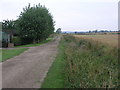
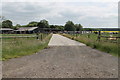
Track to Hud Holes
This farm track becomes a footpath for some of its journey to Hud Holes.
Image: © Michael Patterson
Taken: 26 Aug 2006
0.18 miles