IMAGES TAKEN NEAR TO
Kenwick, LOUTH, LN11 8NW
Introduction
This page details the photographs taken nearby to LN11 8NW by members of the Geograph project.
The Geograph project started in 2005 with the aim of publishing, organising and preserving representative images for every square kilometre of Great Britain, Ireland and the Isle of Man.

There are currently over 7.5m images from over14,400 individuals and you can help contribute to the project by visiting https://www.geograph.org.uk
Image Map (Loading...)


Getting Data...Please wait
Leaflet Map data © OpenStreetMap
Images are licensed for reuse under creativecommons.org/licenses/by-sa/2.0
Notes
- Clicking on the map will re-center to the selected point.
- The higher the marker number, the further away the image location is from the centre of the postcode.
Image Listing (11 Images Found)
Images are licensed for reuse under creativecommons.org/licenses/by-sa/2.0
Image
Details
Distance
1
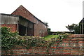
Kenwick Thorpe Farm: old buildings over an ivy covered wall
Image: © Chris
Taken: 14 Oct 2012
0.03 miles
2
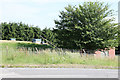
Reservoir by the A157
Taken from the opposite side of the road.
Image: © Andrew Whale
Taken: 4 Jul 2010
0.10 miles
3
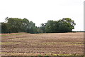
Saturday Pits: "where you went to dump stuff on Saturday"
One person I ran into had heard of it!
There was a sign there until a few years ago, but the history of the Saturday Pits goes back a very long way - they are marked "Saturday Pits (Whiting Works)", behind Southfield Cottages, on the 1889 O.S. map.
Also see: www.culturegrid.org.uk/static/showResource/3882187
"PRN 45523 Quarry pits... This area was used as a whiting works, where chalk would be washed and crushed to make whitewash for houses...This area was also used as a temporary market when the town markets were suspended because of plague in the mid-seventeenth century. "
Not sure if in more recent times it was private i.e. if you paid to dump there.
This was the entrance, near Kenwick Thorpe Farm.
One thing's for certain: the name must have given the Council ideas: the Recycling facility in Louth no longer opens daily. Soon we shall be back to dumping stuff on Saturdays!
Image: © Chris
Taken: 14 Oct 2012
0.12 miles
4
Saturday Pits: "where you went to dump stuff on Saturday"
This was the entrance.
One person I ran into had heard of the Saturday Pits!
There was a sign there until a few years ago, but the history of the Saturday Pits goes back a very long way - they are marked "Saturday Pits (Whiting Works)", behind Southfield Cottages, on the 1889 O.S. map.
Also see: www.culturegrid.org.uk/static/showResource/3882187
"PRN 45523 Quarry pits... This area was used as a whiting works, where chalk would be washed and crushed to make whitewash for houses...This area was also used as a temporary market when the town markets were suspended because of plague in the mid-seventeenth century. "
It was certainly in use as a whiting, or whitening, pit before and during WW2. In 1992 the former manager of the pit, Mr.Harold Wilson, was still living in the end cottage of the block of 4 near the entrance. During the last war a German bomber returning from a raid in the Midlands dropped a stick of incendiary bombs which hit some of the buildings in the quarry, as well as setting fire to a dismantled aircraft on the adjacent field, which was used as an airstrip (Wright's Aerodrome). See: Image; Image; http://geoffandwinnwright.blogspot.co.uk/2008_05_01_archive.html
Not sure if in more recent times the tip was private i.e. if you paid to dump there.
One thing's for certain: the name must have given the Council ideas: the Recycling facility in Louth no longer opens daily. Soon we may be back to dumping stuff on Saturdays!
Image: © Chris
Taken: 14 Oct 2012
0.12 miles
6
Wright's Aerodrome, Kenwick Road, Louth 1936
This is the site of Fred Wright's Aerodrome in 1936. The quarry is at the top of the picture. The hangar was at bottom right and contained an Avro 504k biplane, 1919 vintage, G-ACRE, and a Flying Flea. The company was called Lincolnshire Flying Services and toured along the east coast giving joyrides at 2/6, 5/0 and 7/6 for aerobatics. The hangar is still in existence as a garage on the Lincoln Road at Welton.
Image: © Geoff Wright
Taken: 1 Aug 1999
0.15 miles
9
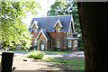
North Lodge
North Lodge viewed from the public footpath within Kenwick Park grounds.
Image: © Andrew Whale
Taken: 4 Jul 2010
0.18 miles
