IMAGES TAKEN NEAR TO
Haywood Cottages, LOUTH, LN11 8JH
Introduction
This page details the photographs taken nearby to Haywood Cottages, LN11 8JH by members of the Geograph project.
The Geograph project started in 2005 with the aim of publishing, organising and preserving representative images for every square kilometre of Great Britain, Ireland and the Isle of Man.

There are currently over 7.5m images from over14,400 individuals and you can help contribute to the project by visiting https://www.geograph.org.uk
Image Map
Images are licensed for reuse under creativecommons.org/licenses/by-sa/2.0
Notes
- Clicking on the map will re-center to the selected point.
- The higher the marker number, the further away the image location is from the centre of the postcode.
Image Listing (19 Images Found)
Images are licensed for reuse under creativecommons.org/licenses/by-sa/2.0
Image
Details
Distance
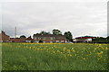
1
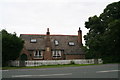
Cottages at South Reston
The sandstone datestone has been eroded by the weather and is illegible.
Image: © Chris
Taken: 3 Jul 2013
0.01 miles
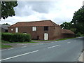
5

Main Road (A157), South Reston
Towards Mablethorpe.
Image: © JThomas
Taken: 22 Jun 2013
0.10 miles
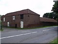
6
Round the bend in South Reston
Viewed from the footpath from Castle Carlton.
This is the right-angle bend at the exit from the village.
On right is the former petrol station.
Image: © Chris
Taken: 3 Jul 2013
0.11 miles
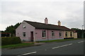
8
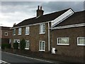
Cottage on Main Road, South Reston
This cottage at the north-west end of the village, on the A157 has a cut benchmark near its west angle, close to a down pipe. See https://www.geograph.org.uk/photo/6224652 for a closer view and https://www.bench-marks.org.uk/bm108789 for details.
Image: © Brian Westlake
Taken: 20 Jun 2019
0.12 miles
9
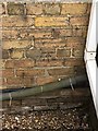
Cut Mark: South Reston, Main Road
A cottage at the north-west end of the village, on the A157 has a cut benchmark near its west angle, close to a down pipe. See https://www.geograph.org.uk/photo/6224655 for a wider view and https://www.bench-marks.org.uk/bm108789 for details.
Image: © Brian Westlake
Taken: 20 Jun 2019
0.12 miles
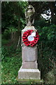
10
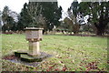
St.Edith's churchyard, South Reston, Lincs.
The parishioners of South Reston built a new church here by James Fowler in 1864 ..... it was shamelessly pulled down in 1983. The splendid Perpendicular font with eight heads marks the site, surrounded by the graves of parishioners who most probably worshipped in the church. One of many demolished churches in this part of Lincolnshire.
Image: © Richard Croft
Taken: 18 Jan 2006
0.13 miles