IMAGES TAKEN NEAR TO
Castle Carlton, LOUTH, LN11 8JE
Introduction
This page details the photographs taken nearby to LN11 8JE by members of the Geograph project.
The Geograph project started in 2005 with the aim of publishing, organising and preserving representative images for every square kilometre of Great Britain, Ireland and the Isle of Man.

There are currently over 7.5m images from over14,400 individuals and you can help contribute to the project by visiting https://www.geograph.org.uk
Image Map (Loading...)


Getting Data...Please wait
Leaflet Map data © OpenStreetMap
Images are licensed for reuse under creativecommons.org/licenses/by-sa/2.0
Notes
- Clicking on the map will re-center to the selected point.
- The higher the marker number, the further away the image location is from the centre of the postcode.
Image Listing (5 Images Found)
Images are licensed for reuse under creativecommons.org/licenses/by-sa/2.0
Image
Details
Distance
1
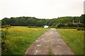
Woodlands
House called Woodlands hidden in Castle Wood at Castle Carlton
Image: © Richard Croft
Taken: 13 Jun 2007
0.12 miles
2
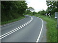
Sharp bend in the A157
Towards Mablethorpe.
Image: © JThomas
Taken: 22 Jun 2013
0.15 miles
4
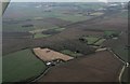
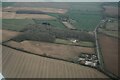
Castle Carlton: aerial 2016
The Motte and Baileys were in the wood next to the ponds.
Manby disused airfield at the top.
Image: © Chris
Taken: 18 Dec 2016
0.19 miles