IMAGES TAKEN NEAR TO
Lacey Gardens, LOUTH, LN11 8DG
Introduction
This page details the photographs taken nearby to Lacey Gardens, LN11 8DG by members of the Geograph project.
The Geograph project started in 2005 with the aim of publishing, organising and preserving representative images for every square kilometre of Great Britain, Ireland and the Isle of Man.

There are currently over 7.5m images from over14,400 individuals and you can help contribute to the project by visiting https://www.geograph.org.uk
Image Map (Loading...)


Getting Data...Please wait
Leaflet Map data © OpenStreetMap
Images are licensed for reuse under creativecommons.org/licenses/by-sa/2.0
Notes
- Clicking on the map will re-center to the selected point.
- The higher the marker number, the further away the image location is from the centre of the postcode.
Image Listing (75 Images Found)
Images are licensed for reuse under creativecommons.org/licenses/by-sa/2.0
Image
Details
Distance
1
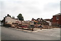
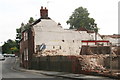
The destruction of the historic Winch's Brewery
This site consisted of Winch's brewery, which dated from the middle of the 19th century, and the former Allinsons Print Works and shop.
These were part of a historic row of buildings, including the brewer's house and the spring-fed swimming pool. See: Image and Image
Lest we should forget what has been destroyed, effectively taking out the end of the row, see Image and Image
Originally William East's brewery (he lived up the road, see TF3387 : William East's house in Church Street), it was taken over in the 1880's by T.M.Winch and Co.(as seen here). Then it continued as Soulby Sons and Winch until 1910. The water for the beer came from Aswell Spring, which flowed through the Gatherums from Aswell Street, also supplying the open air swimming pool next door.
The applicant said the property had been on the market for nearly 7 years, and not sold and that the condition was "worsening".
The Victorian Society objected strongly to the plans. Nevertheless, though the first application was not successful, East Lindsey District Council allowed the second, thus sanctioning the destruction of this historic buildings.
Housing is to be built on the site.
A similar fate befell the chimney in Cinder Lane, which after being abandoned for 7 years was declared to be unsafe, so that the Council felt it had no option but to allow it to be demolished.
Image: © Chris
Taken: 22 Jul 2014
0.05 miles
2
The destruction of the historic Winch's Brewery
This site consisted of Winch's brewery, which dated from the middle of the 19th century, and the former Allinsons Print Works and shop.
These were part of a historic row of buildings, including the brewer's house and the spring-fed swimming pool. See: Image and Image
Lest we should forget what has been destroyed, effectively taking out the end of the row, see Image and Image
Originally William East's brewery (he lived up the road, see TF3387 : William East's house in Church Street), it was taken over in the 1880's by T.M.Winch and Co.(as seen here). Then it continued as Soulby Sons and Winch until 1910. The water for the beer came from Aswell Spring, which flowed through the Gatherums from Aswell Street, also supplying the open air swimming pool next door.
The applicant said the property had been on the market for nearly 7 years, and not sold and that the condition was "worsening".
The Victorian Society objected strongly to the plans. Nevertheless, though the first application was not successful, East Lindsey District Council allowed the second, thus sanctioning the destruction of this historic buildings.
Housing is to be built on the site.
A similar fate befell the chimney in Cinder Lane, which after being abandoned for 7 years was declared to be unsafe, so that the Council said it had no option but to allow it to be demolished.
Image: © Chris
Taken: 22 Jul 2014
0.06 miles
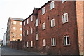
3
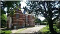
The Lodge - before
The building behind the church lies expectantly waiting for its next incarnation.
Image: © Ian Paterson
Taken: 1 Jun 2021
0.07 miles
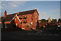
4
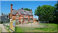
The Lodge at The Rowans
Fenced off and awaiting redevelopment.
Image: © Ian Paterson
Taken: 1 Jun 2021
0.08 miles
5
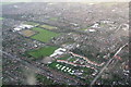
Lacey Gardens and Leisure Centre, Louth: aerial 2015
The wide road bottom left is St. Bernard's Avenue, with its junction with Eastgate (bottom right). The lyre-shaped cul-de-sac of white houses above the caravan storage field is Lacey Gardens, with the Lacey Gardens Primary School and Eastfield Infants' School at the top. Holy Trinity Church just above, on Eastgate.
St.Bernard's Avenue curves around to the right with the Leisure Centre next to it.
Right corner is Monks Dyke School.
Image: © Chris
Taken: 25 Jan 2015
0.08 miles
6
Louth Riverhead
On Eastgate, level with the end of the Louth Navigation, are these fine brick warehouses, now mostly converted to housing.
Image: © Chris
Taken: 21 Apr 2011
0.08 miles
7
Louth Riverhead, Bryan Hall Mill, and Holy Trinity Church
For details of the Mill see:Image]; http://www.guardian.co.uk/news/2006/jan/18/obituaries.mainsection
Holy Trinity Church looks a strange shape because it was remodelled by a fire in 1991: all but the tower was destroyed. http://www.flickr.com/photos/megaspanti/5428544138/
A Community Centre has now been built onto the side of the tower.
Image: © Chris
Taken: 7 Aug 2012
0.10 miles
8
Former Riverhead Methodist Church , Commercial Road Louth
This is at the back of the "Old Mill Park", in the road leading off Riverhead Road. The estate contains a complex named "Old Chapel Mews".
See Image]
Update: In September 2019 I received this message from a lady in respect of this photo: "I found this site by chance, I used to attend Riverhead Methodist Church as a child - but left Louth at age 18. Now I am 81 but remember Louth with affection. I have visited occasionally but no family there now. Many memories!"
Image: © Chris
Taken: 7 Aug 2012
0.13 miles
9
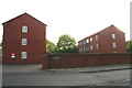
Louth Riverhead, Forlander Place
A new development "sympathetically" designed in the style of the existing warehouses and named after "The Annie Forlander", a barge which plied its trade from the Riverhead from 1892-1909. See photo 3070254.
Image: © Chris
Taken: 21 Apr 2011
0.13 miles
10
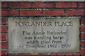
Louth Riverhead, Forlander Place: detail
See Photo no.3070249. This is in the wall outside new development "sympathetically" designed in the style of the existing warehouses At the Riverhead.
Image: © Chris
Taken: 21 Apr 2011
0.13 miles