IMAGES TAKEN NEAR TO
Park Avenue, LOUTH, LN11 8BX
Introduction
This page details the photographs taken nearby to Park Avenue, LN11 8BX by members of the Geograph project.
The Geograph project started in 2005 with the aim of publishing, organising and preserving representative images for every square kilometre of Great Britain, Ireland and the Isle of Man.

There are currently over 7.5m images from over14,400 individuals and you can help contribute to the project by visiting https://www.geograph.org.uk
Image Map (Loading...)


Getting Data...Please wait
Leaflet Map data © OpenStreetMap
Images are licensed for reuse under creativecommons.org/licenses/by-sa/2.0
Notes
- Clicking on the map will re-center to the selected point.
- The higher the marker number, the further away the image location is from the centre of the postcode.
Image Listing (59 Images Found)
Images are licensed for reuse under creativecommons.org/licenses/by-sa/2.0
Image
Details
Distance
2
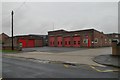
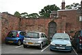
Louth fire station
Louth fire station, Eastfield Road, Louth, Lincolnshire
Image: © Kevin Hale
Taken: 4 Aug 2010
0.05 miles
4
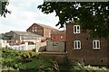
Louth Riverhead
There are many fine historic buildings alongside the Louth Navigation.
This one is in Thames St. Parts of it have been better preserved than others.
The buildings at the far end of this block were once Baines' Mill and the Louth Gaslight Company.
As the gas works expanded, it began to encraoch on Baines' land, and in 1878 Baines set a stone into the edge of his building to mark the boundary.
Image: © Chris
Taken: 21 Apr 2011
0.12 miles
5
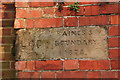
Louth Riverhead, Baines' Mill boundary marker
This stone marks the boundary between Baines' Mill and the Louth Gaslight Company (See photo 3069990)
As the gas works expanded, it began to encroach on Baines' land, and in 1878 Baines set a stone into the edge of his building to mark the boundary.
Image: © Chris
Taken: 21 Apr 2011
0.12 miles
6
Door off Lucern Court, near Louth Riverhead (2)
Formerly gave access to the canal for the inhabitant of the house on the other side.
Image: © Chris
Taken: 13 Sep 2020
0.12 miles
7
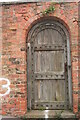
Door off Lucern Court, near Louth Riverhead (1)
Formerly gave access to the canal for the inhabitant of the house on the other side.
Image: © Chris
Taken: 13 Sep 2020
0.12 miles
8
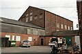
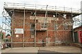
Former coking plant behind Thames Street, Louth
The tall building. Once a steam oil and cake mill. Inititially owned by Baines, but later bought by Robert Norfolk.
Taken during a walk led by local historian Stuart Sizer on the occasion of the Louth Navigation Trust's 2020 Heritage and Arts Festival
Image: © Chris
Taken: 13 Sep 2020
0.13 miles
9
Across the Louth Canal to the former coking plant
See Image
Image: © Chris
Taken: 13 Sep 2020
0.13 miles
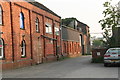
10
Baines Flour Mill in Thames Street opposite the Louth Canal
Former water mill - the River Lud used to run past the front of it parallel to the Louth Navigation. Corn was brought to the mill by barge or cart for grinding. Under the west boundary was a 4' tunnel running from the river to the canal. This was used to "top up" the canal basin. A listed building in a sorry condition.
Taken during a walk led by local historian Stuart Sizer on the occasion of the Louth Navigation Trust's 2020 Heritage and Arts Festival.
See https://historicengland.org.uk/listing/the-list/list-entry/1078197
Image: © Chris
Taken: 13 Sep 2020
0.13 miles