IMAGES TAKEN NEAR TO
Mill Lane, LOUTH, LN11 7TW
Introduction
This page details the photographs taken nearby to Mill Lane, LN11 7TW by members of the Geograph project.
The Geograph project started in 2005 with the aim of publishing, organising and preserving representative images for every square kilometre of Great Britain, Ireland and the Isle of Man.

There are currently over 7.5m images from over14,400 individuals and you can help contribute to the project by visiting https://www.geograph.org.uk
Image Map (Loading...)


Getting Data...Please wait
Leaflet Map data © OpenStreetMap
Images are licensed for reuse under creativecommons.org/licenses/by-sa/2.0
Notes
- Clicking on the map will re-center to the selected point.
- The higher the marker number, the further away the image location is from the centre of the postcode.
Image Listing (33 Images Found)
Images are licensed for reuse under creativecommons.org/licenses/by-sa/2.0
Image
Details
Distance
1
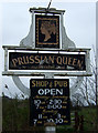
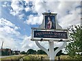
Sign for the Prussian Queen, Saltfleetby All Saints
Image: © JThomas
Taken: 21 Mar 2015
0.03 miles
4
The sign of the Prussian Queen
For an excellent description of the (former) pub and the origin of the name see Image
For as it is as this picture was taken Image
Image: © David Lally
Taken: 21 Aug 2022
0.03 miles
5
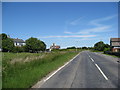
Approaching "The Prussian Queen" on the B1200
Image: © Alan Heardman
Taken: 21 Jun 2010
0.03 miles
6
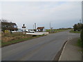
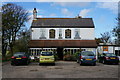
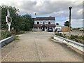
Main Road (B1200) and The Prussian Queen PH at Saltfleetby All Saints
Looking north-eastward.
Image: © Peter Wood
Taken: 1 Mar 2019
0.03 miles
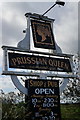
7
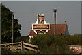
Prussian Queen pub sign
For history and that of the name see Richard Croft's 2010 photo: Image
It is also worth adding that in 1953 a practice bomb (smoke bomb) destined for the bombing target range at nearby Donna Nook went through the toilet window of the Prussian Queent. Rightly might this loo be nicknamed a thunder box!
See: http://hansard.millbanksystems.com/commons/1953/nov/19/bombing-range-saltfleet
Image: © Chris
Taken: 5 Sep 2013
0.03 miles
8
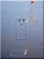
OS Flush Bracket S0606 - Saltfleetby
Located on the former outside wall of The Prussian Queen pub, which is now an interior wall since being enclosed by a front extension to the building. It was last levelled in 1970 at 2.858m above Ordnance Datum Newlyn.
Image: © Richard Law
Taken: 25 May 2023
0.04 miles
9
The Prussian Queen or The Wick or neither
Now appears to be a private dwelling.
There doesn't appear to be any photos of The Wick when it was, presumably a restaurant. But two aa the public house https://www.geograph.org.uk/stuff/list.php?title=The+Prussian+Queen&gridref=TF4590
The sign still remains Image
Image: © David Lally
Taken: 21 Aug 2022
0.04 miles