IMAGES TAKEN NEAR TO
Saltfleetby, LOUTH, LN11 7TB
Introduction
This page details the photographs taken nearby to LN11 7TB by members of the Geograph project.
The Geograph project started in 2005 with the aim of publishing, organising and preserving representative images for every square kilometre of Great Britain, Ireland and the Isle of Man.

There are currently over 7.5m images from over14,400 individuals and you can help contribute to the project by visiting https://www.geograph.org.uk
Image Map (Loading...)


Getting Data...Please wait
Leaflet Map data © OpenStreetMap
Images are licensed for reuse under creativecommons.org/licenses/by-sa/2.0
Notes
- Clicking on the map will re-center to the selected point.
- The higher the marker number, the further away the image location is from the centre of the postcode.
Image Listing (28 Images Found)
Images are licensed for reuse under creativecommons.org/licenses/by-sa/2.0
Image
Details
Distance
1

Leaning trees by a moat at Saltfleetby St. Peter (3)
Image: © Chris
Taken: 11 Mar 2018
0.04 miles
2
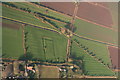
Moated site and ridge and furrow by St. Peter's Church, Saltfleetby: aerial 2018
Moat is full following heavy rain.
Image: © Chris
Taken: 13 Mar 2018
0.05 miles
3
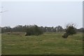
Leaning trees by a moat at Saltfleetby St. Peter (2)
Image: © Chris
Taken: 11 Mar 2018
0.06 miles
4
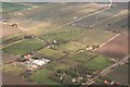
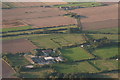
Saltfleetby St. Peter, old church of St. Peter and moated site: aerial 2015
Looking across (northwards) the B1200 and Mar Dyke. The church is in the trees at the bottom with the disused railway behind, and some fields of ridge and furrow, and old ditched enclosure. Possible Medieval settlement, in the form of enclosures and crofts. See: http://www.pastscape.org.uk/hob.aspx?a=0&hob_id=1062097&rational=m&maplat=53.38670000&maplong=0.15550000&mapist=ll&mapilo=0.1555&mapila=53.3867&mapiloe=e&mapilan=n&mapios=TF433899&mapigrn=389956&mapigre=543337&mapipc=&mapisa=250&recordsperpage=10&sort=2#aRt
See also aerial shot Image
The ridge and furrow field on the right is shown from the ground in Image
Image: © Chris
Taken: 27 Dec 2015
0.07 miles
5
Moated site and ridge and furrow by St. Peter's Church, Saltfleetby: aerial 2018 (2)
Moat and furrows are filled following heavy rain.
Image: © Chris
Taken: 13 Mar 2018
0.08 miles
6

Leaning trees by a moat at Saltfleetby St. Peter (1)
Image: © Chris
Taken: 11 Mar 2018
0.08 miles
7
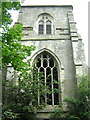
Remains of old St Peter's Church, Charles Gate, Saltfleetby St Peter
St Peter's church used to be here, where the cemetery remains, on the corner of Charles Gate and Salter Gate. However, in 1877, due to subsidence, all of the church except the tower was moved to its new location on the corner of North End Lane and Main Road.
The tower, known locally as 'The Stump, is administered by the Friends of Redundant Churches group.
Image: © Mark Morton
Taken: 4 Jun 2005
0.09 miles
8
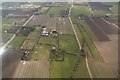
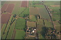
Saltfleetby St. Peter, old church of St. Peter and moated site: aerial 2015
Looking across the B1200 and Mar Dyke. The church is in the trees centre right with the disused railway behind, and some fields of ridge and furrow, and old ditched enclosure. Possible Medieval settlement, in the form of enclosures and crofts. See: http://www.pastscape.org.uk/hob.aspx?a=0&hob_id=1062097&rational=m&maplat=53.38670000&maplong=0.15550000&mapist=ll&mapilo=0.1555&mapila=53.3867&mapiloe=e&mapilan=n&mapios=TF433899&mapigrn=389956&mapigre=543337&mapipc=&mapisa=250&recordsperpage=10&sort=2#aRt
More aerial shots: Image and Image
The field on the right is shown from the ground in Image
Image: © Chris
Taken: 19 Sep 2015
0.09 miles
9
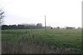
Saltfleetby St. Peter, old church of St. Peter and moated site: aerial 2015
Looking up (eastwards) the B1200 and Mar Dyke. The church is in the trees in the centre with the disused railway left, and some fields of ridge and furrow, and old ditched enclosure. Possible Medieval settlement, in the form of enclosures and crofts. See: http://www.pastscape.org.uk/hob.aspx?a=0&hob_id=1062097&rational=m&maplat=53.38670000&maplong=0.15550000&mapist=ll&mapilo=0.1555&mapila=53.3867&mapiloe=e&mapilan=n&mapios=TF433899&mapigrn=389956&mapigre=543337&mapipc=&mapisa=250&recordsperpage=10&sort=2#aRt
See also aerial shots Image and Image
The ridge and furrow field at the top is shown from the ground in Image
Image: © Chris
Taken: 27 Dec 2015
0.09 miles
10
Moated site at Saltfleetby St. Peter
Image: © Chris
Taken: 11 Mar 2018
0.10 miles