IMAGES TAKEN NEAR TO
North End, LOUTH, LN11 7SX
Introduction
This page details the photographs taken nearby to North End, LN11 7SX by members of the Geograph project.
The Geograph project started in 2005 with the aim of publishing, organising and preserving representative images for every square kilometre of Great Britain, Ireland and the Isle of Man.

There are currently over 7.5m images from over14,400 individuals and you can help contribute to the project by visiting https://www.geograph.org.uk
Image Map
Images are licensed for reuse under creativecommons.org/licenses/by-sa/2.0
Notes
- Clicking on the map will re-center to the selected point.
- The higher the marker number, the further away the image location is from the centre of the postcode.
Image Listing (15 Images Found)
Images are licensed for reuse under creativecommons.org/licenses/by-sa/2.0
Image
Details
Distance
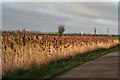
2
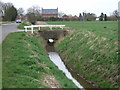
Drain beside North End Lane
Looking south east.
Image: © JThomas
Taken: 21 Mar 2015
0.05 miles
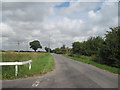
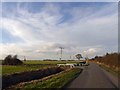
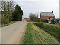
4
Junction of Ings Lane and North End Lane
Image: © J.Hannan-Briggs
Taken: 6 Oct 2013
0.06 miles
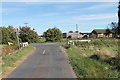
6
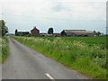
Ings Lane and Poplar Cottage, Saltfleetby St Peter
Looking westwards from the junction of Ings Lane and North End Lane.
Image: © Mark Morton
Taken: 4 Jun 2005
0.10 miles
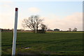
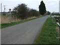
9
North End Lane at Fern Cottage
Looking south-eastward.
Image: © Peter Wood
Taken: 1 Mar 2019
0.16 miles
10
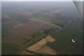
North end, Saltfleetby St. Peter: aerial 2015
Crossing the road by the narrow triangular field is the course of the old Mablethorpe Loop railway from Louth.
Image: © Chris
Taken: 12 Feb 2015
0.16 miles