IMAGES TAKEN NEAR TO
The Hill, LOUTH, LN11 7RJ
Introduction
This page details the photographs taken nearby to The Hill, LN11 7RJ by members of the Geograph project.
The Geograph project started in 2005 with the aim of publishing, organising and preserving representative images for every square kilometre of Great Britain, Ireland and the Isle of Man.

There are currently over 7.5m images from over14,400 individuals and you can help contribute to the project by visiting https://www.geograph.org.uk
Image Map
Images are licensed for reuse under creativecommons.org/licenses/by-sa/2.0
Notes
- Clicking on the map will re-center to the selected point.
- The higher the marker number, the further away the image location is from the centre of the postcode.
Image Listing (61 Images Found)
Images are licensed for reuse under creativecommons.org/licenses/by-sa/2.0
Image
Details
Distance

3
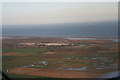
Saltfleet: aerial 2014
Note the white cap of the windmill centre front of the village.
Humber Gateway Offshore Windfarm in the distance.
For aerial films of this area see: https://www.youtube.com/watch?v=wwhVamd4j6E and https://www.youtube.com/watch?v=zZjqzcMFXi8
These are LiDAR films of the Wolds and Marshes east of Louth. The films are narrated by Jim Broadbent. The land is colour-coded according to its elevation. The films show how the landscape was reclaimed for salt making and grazing. Footage includes ancient river systems, settlements, salterns and ridge and furrow. Produced for the Lincolnshire Coastal Grazing Marshes Project, which has now terminated.
More Humber Gateway Windfarm photos in Image
Image: © Chris
Taken: 6 Dec 2014
0.04 miles
4
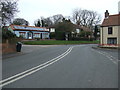
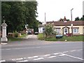
Main Road (A1031), Saltfleet
Passing the Crown Inn public house.
Image: © JThomas
Taken: 21 Mar 2015
0.04 miles
5
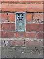
OS flush bracket S0604 in Saltfleet
Located on the corner of Image and installed during the Third Geodetic Levelling of the country in 1959 at 6.416m above Ordnance Datum Newlyn.
Image: © Richard Law
Taken: 23 May 2023
0.05 miles
6
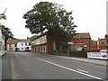
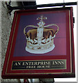
Saltfleet - The Crown Inn
A friendly reception and a good meal.
Image: © Alan Heardman
Taken: 17 Sep 2009
0.05 miles