IMAGES TAKEN NEAR TO
Eau Bank, LOUTH, LN11 7LP
Introduction
This page details the photographs taken nearby to Eau Bank, LN11 7LP by members of the Geograph project.
The Geograph project started in 2005 with the aim of publishing, organising and preserving representative images for every square kilometre of Great Britain, Ireland and the Isle of Man.

There are currently over 7.5m images from over14,400 individuals and you can help contribute to the project by visiting https://www.geograph.org.uk
Image Map
Images are licensed for reuse under creativecommons.org/licenses/by-sa/2.0
Notes
- Clicking on the map will re-center to the selected point.
- The higher the marker number, the further away the image location is from the centre of the postcode.
Image Listing (11 Images Found)
Images are licensed for reuse under creativecommons.org/licenses/by-sa/2.0
Image
Details
Distance
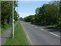
1
Eau Bank looking north
From close to junction with Conisholme Road (A1031)
Image: © John Firth
Taken: 11 Jul 2011
0.02 miles
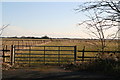
2
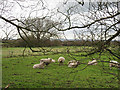
Sheep Near Eau Bank Farm
The lane adjacent to the field of sheep is called Eau Bank.
Image: © Roger Gilbertson
Taken: 5 Dec 2006
0.10 miles
3
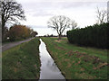
The Drain Beside Eau Bank
Drains and banks proliferate in the exceedingly flat land in the area.
Image: © Roger Gilbertson
Taken: 5 Dec 2006
0.13 miles
4
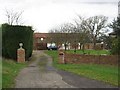
The Entrance To Braygate House
On the main road at the end of Eau Bank.
Image: © Roger Gilbertson
Taken: 5 Dec 2006
0.13 miles
7
Sheep on the grazing marshes by Braygate Bridge
Image: © Chris
Taken: 13 Feb 2014
0.18 miles
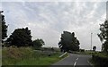
8
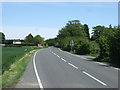
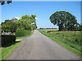
Conisholme Road (A1031)
Towards Mablethorpe.
Image: © JThomas
Taken: 25 May 2013
0.19 miles