IMAGES TAKEN NEAR TO
Biergate Lane, LOUTH, LN11 7LA
Introduction
This page details the photographs taken nearby to Biergate Lane, LN11 7LA by members of the Geograph project.
The Geograph project started in 2005 with the aim of publishing, organising and preserving representative images for every square kilometre of Great Britain, Ireland and the Isle of Man.

There are currently over 7.5m images from over14,400 individuals and you can help contribute to the project by visiting https://www.geograph.org.uk
Image Map (Loading...)


Getting Data...Please wait
Leaflet Map data © OpenStreetMap
Images are licensed for reuse under creativecommons.org/licenses/by-sa/2.0
Notes
- Clicking on the map will re-center to the selected point.
- The higher the marker number, the further away the image location is from the centre of the postcode.
Image Listing (7 Images Found)
Images are licensed for reuse under creativecommons.org/licenses/by-sa/2.0
Image
Details
Distance
1
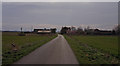
Biergate Farm
As is often the case on the marshes, a long dead-end road leads only to a few buildings.
Image: © Mr T
Taken: 17 Mar 2007
0.07 miles
2
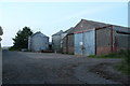
Silos and portal framed building at Biergate Farm
Image: © Chris
Taken: 26 Jul 2013
0.08 miles

5
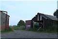
Biergate bridge and farm
Looking east across the bridge over the Louth Navigation: the bridleway and farm track to Biergate Farm and then Grainthorpe.
Image: © Chris
Taken: 31 May 2012
0.19 miles
6

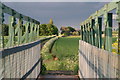
Water Plant and the Road to Biergate Farm
Viewed from the public footbridge over the Louth Canal.
Image: © Ian Paterson
Taken: 9 Nov 2008
0.23 miles
7
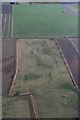
Scrapes on a sheep field off Biergate, Grainthorpe: aerial 2018
The rectangular marks are depressions (scrapes) created for birds (waders) in about 2010 under the terms of Countryside Stewardship Scheme. Apparently it is rare for them to contain water, i.e. they were not very successful, though the sheep enjoy sitting on the vantage point of the "island" in the middle.
The top scrape is in Image
Image: © Chris
Taken: 22 Dec 2018
0.23 miles