IMAGES TAKEN NEAR TO
Louth Park, LOUTH, LN11 7HL
Introduction
This page details the photographs taken nearby to Louth Park, LN11 7HL by members of the Geograph project.
The Geograph project started in 2005 with the aim of publishing, organising and preserving representative images for every square kilometre of Great Britain, Ireland and the Isle of Man.

There are currently over 7.5m images from over14,400 individuals and you can help contribute to the project by visiting https://www.geograph.org.uk
Image Map (Loading...)


Getting Data...Please wait
Leaflet Map data © OpenStreetMap
Images are licensed for reuse under creativecommons.org/licenses/by-sa/2.0
Notes
- Clicking on the map will re-center to the selected point.
- The higher the marker number, the further away the image location is from the centre of the postcode.
Image Listing (3 Images Found)
Images are licensed for reuse under creativecommons.org/licenses/by-sa/2.0
Image
Details
Distance
1
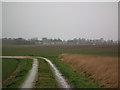
Stewton, footpath to Louth Park Farm
In pouring rain, on the gloomiest of December days.
The footpath branches off to the right at this corner.
Image: © Chris
Taken: 29 Dec 2012
0.07 miles
2
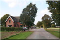
Louth Park Farm cottage
View north from the farm drive and public footpath.
The cottage is undergoing some maintenance.
Image: © Chris
Taken: 10 Oct 2012
0.17 miles
3
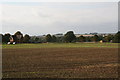
Louth Park Farm cottage and fields
This is the same cottage as in Image, but from a parallel footpath, and the photo also shows an original park-type pasture field with trees.
Image: © Chris
Taken: 10 Oct 2012
0.18 miles