IMAGES TAKEN NEAR TO
Keddington, LOUTH, LN11 7HF
Introduction
This page details the photographs taken nearby to LN11 7HF by members of the Geograph project.
The Geograph project started in 2005 with the aim of publishing, organising and preserving representative images for every square kilometre of Great Britain, Ireland and the Isle of Man.

There are currently over 7.5m images from over14,400 individuals and you can help contribute to the project by visiting https://www.geograph.org.uk
Image Map (Loading...)


Getting Data...Please wait
Leaflet Map data © OpenStreetMap
Images are licensed for reuse under creativecommons.org/licenses/by-sa/2.0
Notes
- Clicking on the map will re-center to the selected point.
- The higher the marker number, the further away the image location is from the centre of the postcode.
Image Listing (5 Images Found)
Images are licensed for reuse under creativecommons.org/licenses/by-sa/2.0
Image
Details
Distance
1
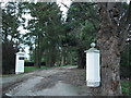
The entrance to Keddington Grange
The lane as far as this entrance is marked as a byway.
There is a moat marked on the map to the right of the entrance, but there was nothing visible through the trees.
Image: © Chris
Taken: 30 Dec 2012
0.03 miles
2
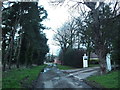
Keddington Grange Farm
The lane as far as this entrance is marked as a byway.
The pine trees which run along the left side of the drive (see Image) are joined by a line of Leyland Cypress at this point, making it very dark in the late afternoon light of the second-last day of the year.
Keddington Grange itself is through the gateway to the right.
There is a moat marked on the map to the right of the entrance, but there was nothing visible through the trees.
Image: © Chris
Taken: 30 Dec 2012
0.05 miles
3
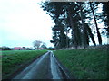
The Lane from Keddington Grange and Farm
The Grange is behind the camera. See: Image; Image
The lane as far as the Grange is marked as a byway.
Late in the afternoon, on the second-last day of the year, and overshadowed by pine trees.
Image: © Chris
Taken: 30 Dec 2012
0.15 miles
4
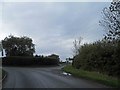
Right turn to the Co-Op farm Keddington, Louth
Image: © Steve Fareham
Taken: 9 Nov 2013
0.16 miles
5
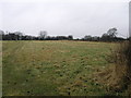
Fields and Hedges
This rough pasture is surrounded by mature hedgerows.
Image: © Michael Patterson
Taken: 8 Mar 2006
0.18 miles