IMAGES TAKEN NEAR TO
Stapes Garth, LOUTH, LN11 7FD
Introduction
This page details the photographs taken nearby to Stapes Garth, LN11 7FD by members of the Geograph project.
The Geograph project started in 2005 with the aim of publishing, organising and preserving representative images for every square kilometre of Great Britain, Ireland and the Isle of Man.

There are currently over 7.5m images from over14,400 individuals and you can help contribute to the project by visiting https://www.geograph.org.uk
Image Map
Images are licensed for reuse under creativecommons.org/licenses/by-sa/2.0
Notes
- Clicking on the map will re-center to the selected point.
- The higher the marker number, the further away the image location is from the centre of the postcode.
Image Listing (19 Images Found)
Images are licensed for reuse under creativecommons.org/licenses/by-sa/2.0
Image
Details
Distance
4
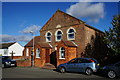
A Ebenezer Methodist Chapel, Grainthorpe
Built in 1818.
Image: © Ian S
Taken: 3 Nov 2013
0.09 miles
5
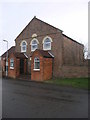
Grainthorpe Methodist
Grainthorpe Methodists Chapel was founded in 1818, I suspect the double glazing has been added since.
Image: © Michael Patterson
Taken: 16 Feb 2007
0.10 miles
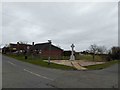
6
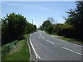
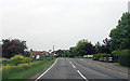
Wragholme Road (A1031)
Towards Mablethorpe.
Image: © JThomas
Taken: 25 May 2013
0.10 miles
7
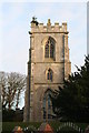
Grainthorpe Church is sprouting a Christmas Tree
Image: © Chris
Taken: 1 Dec 2013
0.10 miles