IMAGES TAKEN NEAR TO
Back Lane, LOUTH, LN11 7ES
Introduction
This page details the photographs taken nearby to Back Lane, LN11 7ES by members of the Geograph project.
The Geograph project started in 2005 with the aim of publishing, organising and preserving representative images for every square kilometre of Great Britain, Ireland and the Isle of Man.

There are currently over 7.5m images from over14,400 individuals and you can help contribute to the project by visiting https://www.geograph.org.uk
Image Map
Images are licensed for reuse under creativecommons.org/licenses/by-sa/2.0
Notes
- Clicking on the map will re-center to the selected point.
- The higher the marker number, the further away the image location is from the centre of the postcode.
Image Listing (15 Images Found)
Images are licensed for reuse under creativecommons.org/licenses/by-sa/2.0
Image
Details
Distance
1
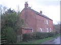
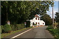
Bee Hive Cottage, North Cockerington
North Cockerington has only two listed buildings and this isn't one of them. But it is one of the older buildings in the village.
Image: © Jonathan Thacker
Taken: 1 Feb 2013
0.03 miles
2
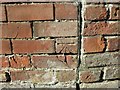
Ordnance Survey Cut Mark
This mark can be found on the wall of a roadside building in Grange Lane, North Cockerington. The benchmark height is calculated as being 10.09 metres above sea level.
For more detail see : https://www.bench-marks.org.uk/bm105528
Image: © Peter Wood
Taken: 27 Feb 2019
0.04 miles
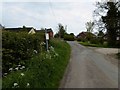
4
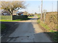
Grange Lane in North Cockerington
Looking north-westward.
Image: © Peter Wood
Taken: 27 Feb 2019
0.09 miles
5
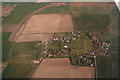
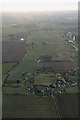
North Cockerington: aerial 2016
Louth Canal running across the top left corner. Green Dike across the top right corner.
Image: © Chris
Taken: 25 Mar 2016
0.11 miles
6
Meadow Lane, North Cockerington
A cottage and a footpath sign at the end of Church Walk. The For Sale sign refers to a house in Church Walk.
The telephone box that used to stand on the corner has now disappeared.
The improvised notice board on the tree is advertising the election of Police and Crime Commissioners next month (November 2012), but nobody seems to know what it is about.
Image: © Chris
Taken: 17 Oct 2012
0.17 miles
7
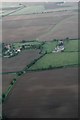
Looking up the Green Dike south of North Cockerington: aerial 2016
Past The Cedars Farm.
Image: © Chris
Taken: 8 Oct 2016
0.17 miles
8
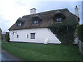
Oak Cottage, North Cockerington
A largely seventeenth century cottage, though much altered in the twentieth century. The ivy will be doing the thatch no good at all! http://www.britishlistedbuildings.co.uk/en-195479-oak-cottage-north-cockerington-lincolnsh
Image: © Jonathan Thacker
Taken: 1 Feb 2013
0.18 miles
9
North Cockerington and Louth Canal: aerial 2018
Image: © Chris
Taken: 7 Feb 2018
0.19 miles