IMAGES TAKEN NEAR TO
Grange Lane, LOUTH, LN11 7EN
Introduction
This page details the photographs taken nearby to Grange Lane, LN11 7EN by members of the Geograph project.
The Geograph project started in 2005 with the aim of publishing, organising and preserving representative images for every square kilometre of Great Britain, Ireland and the Isle of Man.

There are currently over 7.5m images from over14,400 individuals and you can help contribute to the project by visiting https://www.geograph.org.uk
Image Map (Loading...)


Getting Data...Please wait
Leaflet Map data © OpenStreetMap
Images are licensed for reuse under creativecommons.org/licenses/by-sa/2.0
Notes
- Clicking on the map will re-center to the selected point.
- The higher the marker number, the further away the image location is from the centre of the postcode.
Image Listing (19 Images Found)
Images are licensed for reuse under creativecommons.org/licenses/by-sa/2.0
Image
Details
Distance
2
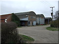
Grange Farm
Looking west on Melholme Lane
Image: © Richard Croft
Taken: 12 May 2007
0.05 miles
4
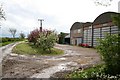
Melholme Lane at Grange Farm
Looking north-eastward.
Image: © Peter Wood
Taken: 27 Feb 2019
0.07 miles
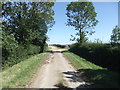
5
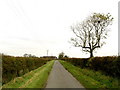
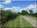
Minor road north of North Cockerington
Image: © Andy Beecroft
Taken: 31 Oct 2007
0.07 miles
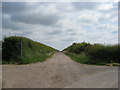
6
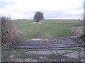
Cattle grid and hedge
This cattle grid at the entrance to two fields saves the need for three gates..
Image: © Jonathan Thacker
Taken: 1 Feb 2013
0.10 miles
7
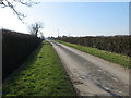
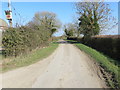
Hedge enclosed Melholme Lane between Grange Farm and Field House
Looking south-westward.
Image: © Peter Wood
Taken: 27 Feb 2019
0.11 miles
8
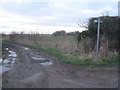
Muddy tracks
To the left is the path to Highbridge Road and going off to the right is Melholme Lane.
Image: © Jonathan Thacker
Taken: 1 Feb 2013
0.13 miles
10
Melholme Lane straight on, becoming Tossey Lane to the right
Image: © Alan Heardman
Taken: 24 Jun 2010
0.15 miles