IMAGES TAKEN NEAR TO
Scupholme, LOUTH, LN11 7EJ
Introduction
This page details the photographs taken nearby to LN11 7EJ by members of the Geograph project.
The Geograph project started in 2005 with the aim of publishing, organising and preserving representative images for every square kilometre of Great Britain, Ireland and the Isle of Man.

There are currently over 7.5m images from over14,400 individuals and you can help contribute to the project by visiting https://www.geograph.org.uk
Image Map (Loading...)


Getting Data...Please wait
Leaflet Map data © OpenStreetMap
Images are licensed for reuse under creativecommons.org/licenses/by-sa/2.0
Notes
- Clicking on the map will re-center to the selected point.
- The higher the marker number, the further away the image location is from the centre of the postcode.
Image Listing (15 Images Found)
Images are licensed for reuse under creativecommons.org/licenses/by-sa/2.0
Image
Details
Distance
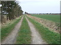
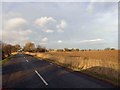
1
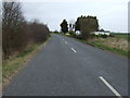
Minor road, Scupholme
Heading north west towards South Somercotes.
Image: © JThomas
Taken: 21 Mar 2015
0.02 miles
4
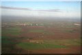
Scupholme to Conisholme Windfarm and the Humber bank: aerial 2017
Windfarm in Image
Image: © Chris
Taken: 8 Nov 2017
0.08 miles
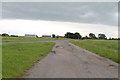
8
The old road past Manor Farm Scupholme
Until the road was straightened, this turn-off was part of the road from South Cockerington to South Somercotes. See also Image
Image: © Chris
Taken: 27 Dec 2012
0.17 miles

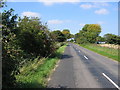
10
Reeds at the roadside near Scupholme
Image: © Steve Fareham
Taken: 17 Jan 2015
0.21 miles