IMAGES TAKEN NEAR TO
Abbey Park, LOUTH, LN11 7BB
Introduction
This page details the photographs taken nearby to Abbey Park, LN11 7BB by members of the Geograph project.
The Geograph project started in 2005 with the aim of publishing, organising and preserving representative images for every square kilometre of Great Britain, Ireland and the Isle of Man.

There are currently over 7.5m images from over14,400 individuals and you can help contribute to the project by visiting https://www.geograph.org.uk
Image Map (Loading...)


Getting Data...Please wait
Leaflet Map data © OpenStreetMap
Images are licensed for reuse under creativecommons.org/licenses/by-sa/2.0
Notes
- Clicking on the map will re-center to the selected point.
- The higher the marker number, the further away the image location is from the centre of the postcode.
Image Listing (33 Images Found)
Images are licensed for reuse under creativecommons.org/licenses/by-sa/2.0
Image
Details
Distance
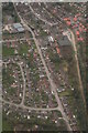
2

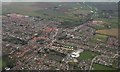
The Death Star lands - a chunk at a time: more new housing in Louth (aerial 2018)
A few years ago a development of nearly 1,000 houses was proposed on the edge of the charming little market town of Louth. The headline in the local paper was "The Death Star landeth". There was a strong reaction among residents and the local council threw the scheme out. However the building fraternity has been more than vindicated by the number of schemes which have since been approved, and the rape of the countryside continues apace. See also Image
Image: © Chris
Taken: 7 Feb 2018
0.12 miles
3
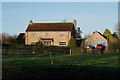
Raven's dark secret
This house was once "The Raven" public house alongside the Louth Navigation. On the far wall the sign still hangs: see Image
Image: © Chris
Taken: 22 Sep 2012
0.13 miles
4
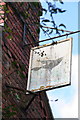
The Raven's dark secret
See Image
The sign still hangs on the end of this house, which was once "The Raven" inn alongside the now disused Louth Navigation.
Image: © Chris
Taken: 22 Sep 2012
0.13 miles
6
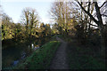
Eastwards along Eastfield Road, the River Lud and the Louth Navigation: aerial 2018
Image: © Chris
Taken: 13 Mar 2018
0.15 miles
7
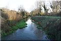
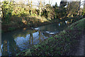
The Louth Canal, River Lud
Heading towards Keddington Corner.
Image: © Ian S
Taken: 18 Dec 2017
0.15 miles
8
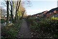
SW along Eastfield Road and the Louth Navigation towards Louth: aerial 2018
Disused canal is well filled following heavy rain.
Image: © Chris
Taken: 13 Mar 2018
0.17 miles