IMAGES TAKEN NEAR TO
Jacklin Lane, LOUTH, LN11 0ZS
Introduction
This page details the photographs taken nearby to Jacklin Lane, LN11 0ZS by members of the Geograph project.
The Geograph project started in 2005 with the aim of publishing, organising and preserving representative images for every square kilometre of Great Britain, Ireland and the Isle of Man.

There are currently over 7.5m images from over14,400 individuals and you can help contribute to the project by visiting https://www.geograph.org.uk
Image Map (Loading...)


Getting Data...Please wait
Leaflet Map data © OpenStreetMap
Images are licensed for reuse under creativecommons.org/licenses/by-sa/2.0
Notes
- Clicking on the map will re-center to the selected point.
- The higher the marker number, the further away the image location is from the centre of the postcode.
Image Listing (27 Images Found)
Images are licensed for reuse under creativecommons.org/licenses/by-sa/2.0
Image
Details
Distance
3
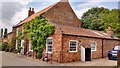
A locomotive in the garage in Fulstow Main Street
This is where Peter Clark restored the "Fulstow", which is operated by Lincolnshire Wolds Railway out of their Ludborough station a mile down the road.
See https://lincolnshirewoldsrailway.co.uk/locomotives. This is a Peckett 0-4-0 [makers number 1749] built in 1928. She spent her working life at Cawdor Quarry, Matlock until withdrawal in 1970. She was restored by Peter Clark in the village of Fulstow in 1988 and was then sold to Great Northern Locomotives Ltd in 1997. 'Fulstow' has just had a ten-year overhaul and she re-entered traffic on 21st November 2010."
Image: © Chris
Taken: 13 Oct 2012
0.06 miles
4
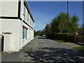
The former Lord Nelson
This former Hewitt's Brewery pub closed in 1969 and is now a private dwelling.
https://www.bygoneboozers.co.uk/post/chronicles-of-a-cat-sitter
Image: © Stewart Marsh
Taken: 7 Jul 2019
0.11 miles
5
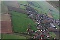
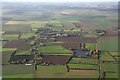
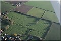
Ridge and furrow and medieval settlement south of Fulstow: aerial 2015
See also Imageand Image
Between Covin's Lane and Main Street. Extends into Image, Image and Image For adjacent field (bottom) see Image
See: http://www.pastscape.org.uk/hob.aspx?hob_id=1066853&sort=2&rational=m&recordsperpage=10&maplat=53.45310000&maplong=0.00190000&mapisa=500&mapist=ll&mapilo=0.0019&mapila=53.4531&mapiloe=e&mapilan=n&mapios=TF329970&mapigrn=397043&mapigre=532917&mapipc=#aRt
Image: © Chris
Taken: 27 Dec 2015
0.12 miles
6
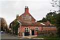
Former Lord Nelson pub in Fulstow Main Street
Image: © Chris
Taken: 13 Oct 2012
0.12 miles
7
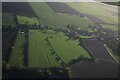
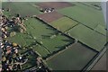
Earthworks and ridge and furrow, Fulstow 2022 (1)
See: https://www.heritagegateway.org.uk/Gateway/Results_Single.aspx?uid=MLI87674&resourceID=1006
Image: © Chris
Taken: 25 Nov 2022
0.16 miles
8
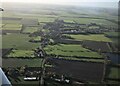
Earthworks and ridge and furrow, Fulstow 2022 (2)
See: https://www.heritagegateway.org.uk/Gateway/Results_Single.aspx?uid=MLI87674&resourceID=1006
Image: © Chris
Taken: 25 Nov 2022
0.16 miles
9
Earthworks and ridge and furrow, Fulstow 2022 (3)
See: https://www.heritagegateway.org.uk/Gateway/Results_Single.aspx?uid=MLI87674&resourceID=1006 and
https://www.heritagegateway.org.uk/Gateway/Results_Single.aspx?uid=MLI87685&resourceID=1006
Image: © Chris
Taken: 25 Nov 2022
0.16 miles
10
Earthworks and ridge and furrow, Fulstow 2022 (4)
See: https://www.heritagegateway.org.uk/Gateway/Results_Single.aspx?uid=MLI87674&resourceID=1006 and
https://www.heritagegateway.org.uk/Gateway/Results_Single.aspx?uid=MLI87685&resourceID=1006
Image: © Chris
Taken: 25 Nov 2022
0.16 miles