IMAGES TAKEN NEAR TO
Fotherby, LOUTH, LN11 0UX
Introduction
This page details the photographs taken nearby to LN11 0UX by members of the Geograph project.
The Geograph project started in 2005 with the aim of publishing, organising and preserving representative images for every square kilometre of Great Britain, Ireland and the Isle of Man.

There are currently over 7.5m images from over14,400 individuals and you can help contribute to the project by visiting https://www.geograph.org.uk
Image Map (Loading...)


Getting Data...Please wait
Leaflet Map data © OpenStreetMap
Images are licensed for reuse under creativecommons.org/licenses/by-sa/2.0
Notes
- Clicking on the map will re-center to the selected point.
- The higher the marker number, the further away the image location is from the centre of the postcode.
Image Listing (20 Images Found)
Images are licensed for reuse under creativecommons.org/licenses/by-sa/2.0
Image
Details
Distance
1
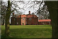
Farmhouse at Fotherby Top
From the bridleway.
Image: © Chris
Taken: 21 Apr 2013
0.01 miles
2
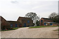
Farm buildings at Fotherby Top
From the bridleway.
Image: © Chris
Taken: 21 Apr 2013
0.04 miles
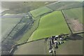
4

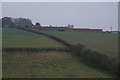
Fotherby Top Farm
Taken from the footpath to North Elkington, this view clearly shows the steepness of the countryside around this area.
Image: © John Beal
Taken: 31 Mar 2007
0.08 miles
6
North Elkington DMV and Fotherby Top: aerial 2022
See: https://www.heritagegateway.org.uk/Gateway/Results_Single.aspx?uid=MLI43581&resourceID=1006
Image: © Simon Tomson
Taken: 25 Nov 2022
0.20 miles
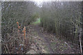
8
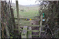
Path or tunnel?
Emerging from the woodland below Fotherby Top
Image: © Neil Theasby
Taken: 17 Apr 2023
0.21 miles
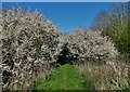
9
Sunlight in the new plantation
The path from Fotherby to the medieval village of North Elkington passes through these young trees.
Image: © Chris
Taken: 21 Apr 2013
0.21 miles
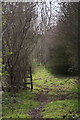
10
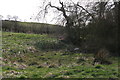
Spring in the valley
This is the first in a line of springs that run through the earthworks connected with the medieval village of North Elkington.
Image: © Chris
Taken: 21 Apr 2013
0.21 miles