IMAGES TAKEN NEAR TO
Waterside, LOUTH, LN11 0US
Introduction
This page details the photographs taken nearby to Waterside, LN11 0US by members of the Geograph project.
The Geograph project started in 2005 with the aim of publishing, organising and preserving representative images for every square kilometre of Great Britain, Ireland and the Isle of Man.

There are currently over 7.5m images from over14,400 individuals and you can help contribute to the project by visiting https://www.geograph.org.uk
Image Map
Images are licensed for reuse under creativecommons.org/licenses/by-sa/2.0
Notes
- Clicking on the map will re-center to the selected point.
- The higher the marker number, the further away the image location is from the centre of the postcode.
Image Listing (63 Images Found)
Images are licensed for reuse under creativecommons.org/licenses/by-sa/2.0
Image
Details
Distance
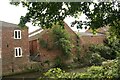
1
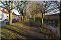
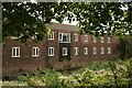
Looking northwards from the Louth Canal to what used to be Eel Mire Lane
The old terrace is lower-lying than the modern housing estate.
Image: © Chris
Taken: 13 Sep 2020
0.05 miles
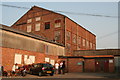
4
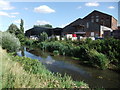
Former Warehouse by the Louth Canal
Now converted to flats and named Willow Court. In 1950's it was used as a glove factory and later a restaurant, which caught fire and burnt the top floor. Hence it is now 2 storeys instead of 3.
Photo taken during a walk led by local historian Stuart Sizer on the occasion of the Louth Navigation Trust's 2020 Heritage and Arts Festival.
Image: © Chris
Taken: 13 Sep 2020
0.06 miles
5

Riverhead, Louth Navigation, after heavy rain: aerial 2018
Image: © Chris
Taken: 13 Mar 2018
0.07 miles
6
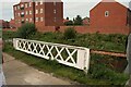
Section of railway bridge used as barrier on Louth Canal
Taken during a walk led by local historian Stuart Sizer on the occasion of the Louth Navigation Trust's 2020 Heritage and Arts Festival.
Information courtesy of local historian Stuart Sizer. Photo taken during a walk led by him on the occasion of the Louth Navigation Trust's 2020 Heritage and Arts Festival.
Image: © Chris
Taken: 13 Sep 2020
0.07 miles
7
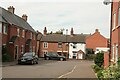
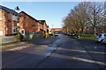
Louth Riverhead, Gaslamp Lounge
There are many old buildings alongside the disused Louth Navigation. These buildings are in Thames Street.
This may seem an unlikely site for a pub, but the building opposite which they are sitting is the Gaslamp Lounge, lit by real gas lights.
An adjacent building to it was once the Louth Gaslight Company, which manufactured its gas from coal transported up the canal.
See http://www.geograph.org.uk/photo/3069960
Image: © Chris
Taken: 21 Apr 2011
0.07 miles
9
Across the Louth Canal to the south bank
Centre is the former coal store for the water mill. See Image
Bottom right of this building in the undergrowth is what I think is the tunnel which ran from the River Lud (through the water mill) into the Canal, and which was used to top up the canal basin. See Image
Image: © Chris
Taken: 13 Sep 2020
0.08 miles